
Fichier:আইয়াং ত্লং.jpg

Fichier d’origine (2 064 × 1 161 pixels, taille du fichier : 339 kio, type MIME : image/jpeg)
Ce fichier et sa description proviennent de Wikimedia Commons.
Description
| Description |
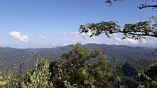
বাংলা: আইয়াং ত্লং বাংলাদেশের একটি পাহাড়চূড়া । বাংলাদেশ – মিয়ানমার সীমান্তে চূড়াটি অবস্থিত।
বান্দরবন জেলার , থাঞ্ছি উপজেলার , ৩৭১ রেমাক্রি মৌজার , দালিয়ান হেডম্যান পাড়ার , আদিবাসী বম সম্প্রদায়ের ভান রউসাং বম , সর্বপ্রথম এই পাহাড়ের সন্ধান পান। ২০১৯ সালের ১৩ই জানুয়ারি , সৌখিন পর্বতারোহী জ্যোতির্ময় ধর , সর্ব প্রথম একজন প্রথম বাংলাদেশী হিসেবে চূড়াটিতে আরোহণ করেন এবং এর অবস্থান নির্ণয় করেন 21°40′23.78″N 92°36′16.01″E । তিনি এই চূড়াটির উচ্চটা পরিমাপ করে পান ৩২৯৮ ফুট।English: The one highest hill of Bangladesh, above 3000 feet has been discovered recently at Thanchi upozila under Bandarban district, claimed Engineer Mr.Jyotirmoy Dhar.
The hill, locally known as “Aiyang Tlang” was measured 3298 feet high above sea level with a Global positioning system (GPS) device, said Engineer Mr.Jyotirmoy Dhar. Earlier 30 years back Mr. Van Rausang Bawm, now 72 years old man from local “Bawm ethnic community” of “Dalian headman para” of “Remakri” mouja, found this hill as a member of Bawm ethnic community. On November 11th 2019, Engineer Jyotirmoy Dhar went to Dalian Headman para of Thanchi upojila and collected proper information about this undiscovered hill and its pick. With the help of local “Bawm” indigenous people, Engineer Jyotirmoy Dhar started his adventure and operation and 13th of November he made the summit in the top peak of this newly discovered hill “Aiyang Tlang”. The hills longitude is 21°40′23.78″N and latitude is 92°36′16.01″E. The location of this newly discovered hill in the middle of Zow Tlang (The unofficially 2nd highest peak of Bangladesh) and Jogi Haphong (another peak above 3000 feet). This newly discovered hill “Aiyang Tlang”, 300 meter inside from Bangladesh –Myanmar border line. The headman (Chairman) of “Dalian headman para” Mr. Lal Ram Bawm” recognized this summit and issued a letter to Engineer Mr. Jyotirmoy Dhar”, as a first Bangladeshi who made first summit to this newly discovered hill and peak “Aiyang Tlang”. This summit and discovery recorded also nearest BGB camp, Engineer Jyotirmoy Dhar said. |
| Date | |
| Source | Travail personnel |
| Auteur | Elmariachictg |
Conditions d’utilisation
- Vous êtes libre :
- de partager – de copier, distribuer et transmettre cette œuvre
- d’adapter – de modifier cette œuvre
- Sous les conditions suivantes :
- paternité – Vous devez donner les informations appropriées concernant l'auteur, fournir un lien vers la licence et indiquer si des modifications ont été faites. Vous pouvez faire cela par tout moyen raisonnable, mais en aucune façon suggérant que l’auteur vous soutient ou approuve l’utilisation que vous en faites.
- partage à l’identique – Si vous modifiez, transformez, ou vous basez sur cette œuvre, vous devez distribuer votre contribution sous la même licence ou une licence compatible avec celle de l’original.
Historique du fichier
Cliquer sur une date et heure pour voir le fichier tel qu'il était à ce moment-là.
| Date et heure | Vignette | Dimensions | Utilisateur | Commentaire | |
|---|---|---|---|---|---|
| actuel | 27 décembre 2019 à 20:54 | | 2 064 × 1 161 (339 kio) | Elmariachictg | User created page with UploadWizard |
Utilisation du fichier
La page suivante utilise ce fichier :
Usage global du fichier
Les autres wikis suivants utilisent ce fichier :
- Utilisation sur bn.wikipedia.org
- Utilisation sur de.wikipedia.org
- Utilisation sur en.wikipedia.org
- Utilisation sur es.wikipedia.org
- Utilisation sur fa.wikipedia.org
- Utilisation sur ru.wikipedia.org
- Utilisation sur www.wikidata.org