
Fichier:Fort Adams, Newport Neck, Newport, Newport County, RI HABS RI,3-NEWP,54- (sheet 2 of 45).tif

Taille de cet aperçu JPG pour ce fichier TIF : 399 × 599 pixels. Autres résolutions : 160 × 240 pixels | 320 × 480 pixels | 512 × 768 pixels | 682 × 1 024 pixels | 1 365 × 2 048 pixels | 9 632 × 14 452 pixels.
Fichier d’origine (9 632 × 14 452 pixels, taille du fichier : 1,01 Mio, type MIME : image/tiff)
Ce fichier et sa description proviennent de Wikimedia Commons.
Description
| HABS RI,3-NEWP,54- (sheet 2 of 45) - Fort Adams, Newport Neck, Newport, Newport County, RI | ||||
|---|---|---|---|---|
| Titre |
HABS RI,3-NEWP,54- (sheet 2 of 45) - Fort Adams, Newport Neck, Newport, Newport County, RI |
|||
| Description |
Totten, Joseph G., Architect; Blutstein, Janet, transmitter; Price, Virginia B, transmitter |
|||
| Lieu représenté | Rhode Island; Newport County; Newport | |||
| Date | Documentation compiled after 1933 | |||
| Dimensions | 24 x 36 in. (D size) | |||
| Lieu actuel |
Library of Congress Prints and Photographs Division Washington, D.C. 20540 USA http://hdl.loc.gov/loc.pnp/pp.print |
|||
| Numéro d’inventaire |
HABS RI,3-NEWP,54- (sheet 2 of 45) |
|||
| Attribution de l’acquisition |
|
|||
| Notes |
|
|||
| Références |
|
|||
| Source | https://www.loc.gov/pictures/item/ri0349.sheet.00002a | |||
| Autorisation (Réutilisation de ce fichier) |
|
|||
| Autres versions |
.png) .png) .png) .png) .png) .png) .png) .png) .png) .png) .png) .png) .png) .png) .png) .png) .png) .png) .png) .png) .png) .png) .png) .png) .png) .png) .png) .png) .png) .png) .png) .png) .png) .png) .png) .png) .png) .png) .png) .png) .png) .png) .png) .png) .png) |
|||

| Position de l'objet | | Voir cet endroit et d’autres images sur : OpenStreetMap |
|---|
Historique du fichier
Cliquer sur une date et heure pour voir le fichier tel qu'il était à ce moment-là.
| Date et heure | Vignette | Dimensions | Utilisateur | Commentaire | |
|---|---|---|---|---|---|
| actuel | 1 août 2014 à 23:06 | 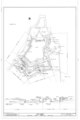 | 9 632 × 14 452 (1,01 Mio) | Fæ | GWToolset: Creating mediafile for Fæ. HABS 31 July 2014 (3000:3200) |
Utilisation du fichier
La page suivante utilise ce fichier :
Usage global du fichier
Les autres wikis suivants utilisent ce fichier :
- Utilisation sur arz.wikipedia.org
- Utilisation sur en.wikipedia.org
- Utilisation sur www.wikidata.org