
Fichier:Pollution over east China.jpg

Fichier d’origine (6 000 × 4 600 pixels, taille du fichier : 2,12 Mio, type MIME : image/jpeg)
Ce fichier et sa description proviennent de Wikimedia Commons.
Description
| Description |
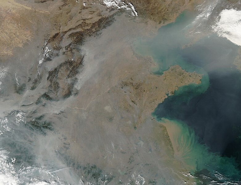
This true-color image over eastern China was acquired by the Moderate Resolution Imaging Spectroradiometer (MODIS), flying aboard NASA’s Aqua satellite, on Oct. 16, 2002 [1]. The scene reveals dozens of fires burning on the surface (red dots) and a thick pall of smoke and haze (greyish pixels) filling the skies overhead. Notice in the high-resolution version of this image how the smog fills the valleys and courses around the contours of the terrain in China’s hilly and mountainous regions. The terrain higher in elevation is less obscured by the smog than the lower lying plains and valleys in the surrounding countryside. This scene spans roughly from Beijing (near top center) to the Yangtze River, the mouth of which can be seen toward the bottom right. Toward the upper right corner, the Bo Hai Bay is rather obscured by the plume of pollution blowing eastward toward Korea and the Pacific Ocean. Toward the bottom right, the Yangtze River is depositing its brownish, sediment-laden waters into the Yellow Sea. |
| Source | |
| Auteur |
Conditions d’utilisation
| Ce fichier provient de la NASA. Sauf exception, les documents créés par la NASA ne sont pas soumis à copyright. Pour plus d'informations, voir la politique de copyright de la NASA. | ||
 |
Attention :
|
Journal des téléversements d’origine
- 2007-03-16 02:27 Kgrr 6000×4600×8 (2227952 bytes) This true-color image over eastern China was acquired by the Moderate Resolution Imaging Spectroradiometer (MODIS), flying aboard NASA’s Aqua satellite, on Oct. 16, 2002 [http://earthobservatory.nasa.gov/Newsroom/NewImages/images.php3?img_id=10795]. Th
Historique du fichier
Cliquer sur une date et heure pour voir le fichier tel qu'il était à ce moment-là.
| Date et heure | Vignette | Dimensions | Utilisateur | Commentaire | |
|---|---|---|---|---|---|
| actuel | 23 mars 2007 à 12:52 | | 6 000 × 4 600 (2,12 Mio) | Liftarn | {{Information |Description=This true-color image over eastern China was acquired by the Moderate Resolution Imaging Spectroradiometer (MODIS), flying aboard NASA’s Aqua satellite, on Oct. 16, 2002 [http://earthobservatory.nasa.gov/Newsroom/NewImages/ima |
Utilisation du fichier
Les 3 pages suivantes utilisent ce fichier :
Usage global du fichier
Les autres wikis suivants utilisent ce fichier :
- Utilisation sur ar.wikipedia.org
- Utilisation sur arz.wikipedia.org
- Utilisation sur ast.wikipedia.org
- Utilisation sur ca.wikipedia.org
- Utilisation sur cs.wikipedia.org
- Utilisation sur en.wikipedia.org
- Utilisation sur es.wikipedia.org
- Utilisation sur eu.wikipedia.org
- Utilisation sur fa.wikipedia.org
- Utilisation sur fi.wikipedia.org
- Utilisation sur fy.wikipedia.org
- Utilisation sur id.wikipedia.org
- Utilisation sur it.wikipedia.org
- Utilisation sur ml.wikipedia.org
- Utilisation sur nl.wikipedia.org
- Utilisation sur no.wikipedia.org
- Utilisation sur oc.wikipedia.org
- Utilisation sur pl.wikipedia.org
- Utilisation sur pt.wikipedia.org
- Utilisation sur si.wikipedia.org
- Utilisation sur sq.wikibooks.org
- Utilisation sur ta.wikipedia.org
- Utilisation sur zh.wikipedia.org