
Fichier:Map of the Gambier Islands and of Prospect Island (Temoe Atoll) by Capt James Duff (retouched).jpg

Taille de cet aperçu : 709 × 600 pixels. Autres résolutions : 284 × 240 pixels | 567 × 480 pixels | 908 × 768 pixels | 1 210 × 1 024 pixels | 2 420 × 2 048 pixels | 2 698 × 2 283 pixels.
Fichier d’origine (2 698 × 2 283 pixels, taille du fichier : 3,34 Mio, type MIME : image/jpeg)
Ce fichier et sa description proviennent de Wikimedia Commons.
_by_Capt_James_Duff_(retouched).jpg?uselang=fr)
Description
| Description |
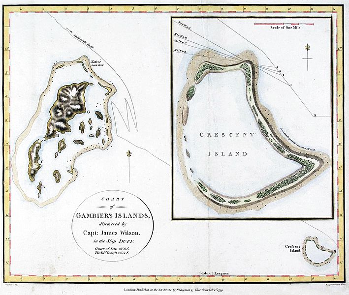
English: maps of the Gambier Islands and of Temoe Atoll (formerly Crescent Island Published in: James Wilson: A Missionary Voyage to the southern Pacific Ocean . . . T. Chapman London, 1799, after page 112 |
| Date | |
| Source | |
| Auteur |
|
_by_Capt._James_Duff.jpg)
| Cette image a été retouchée, ce qui signifie qu'elle a été modifiée par ordinateur et est différente de l'image d'origine. Liste des modifications : distorsion, color, contrast, cropped. Modifications effectuées par Hic et nunc.
|
Conditions d’utilisation
|
Cette œuvre est également dans le domaine public dans tous les pays pour lesquels le droit d’auteur a une durée de vie de 100 ans ou moins après la mort de l’auteur. Cette œuvre est dans le domaine public aux États-Unis car elle a été publiée avant le 1er janvier 1929. | |
| Ce fichier a été identifié comme étant exempt de restrictions connues liées au droit d’auteur, y compris tous les droits connexes et voisins. | |
Historique du fichier
Cliquer sur une date et heure pour voir le fichier tel qu'il était à ce moment-là.
| Date et heure | Vignette | Dimensions | Utilisateur | Commentaire | |
|---|---|---|---|---|---|
| actuel | 27 janvier 2017 à 09:48 | | 2 698 × 2 283 (3,34 Mio) | Hic et nunc | color |
| 27 janvier 2017 à 09:43 |  | 2 698 × 2 283 (3,37 Mio) | Hic et nunc | color | |
| 27 janvier 2017 à 09:27 |  | 2 698 × 2 283 (3,1 Mio) | Hic et nunc | =={{int:filedesc}}== {{Information |description={{en|1=maps of the Gambier Islands and of Temoe Atoll (formerly Crescent Island}} |date=late 1700s to early 1800s |source=*{{Derived from|Map of the Gambier Islands and of Prospect Island (Temoe Atoll) by... |
Utilisation du fichier
Les 2 pages suivantes utilisent ce fichier :
Usage global du fichier
Les autres wikis suivants utilisent ce fichier :
- Utilisation sur de.wikipedia.org
_by_Capt_James_Duff_(retouched).jpg)