
Fichier:Location Ryukyu Islands.PNG

Taille de cet aperçu : 550 × 599 pixels. Autres résolutions : 220 × 240 pixels | 441 × 480 pixels | 906 × 987 pixels.
Fichier d’origine (906 × 987 pixels, taille du fichier : 151 kio, type MIME : image/png)
Ce fichier et sa description proviennent de Wikimedia Commons.
Description
| Description |
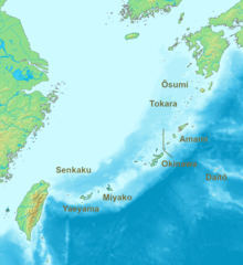
English: Location map of the Ryukyu islands (Nansei islands). According to the standardized geographical names of Japan, the Nansei Islands (南西諸島, Nansei Shotō, lit. "Southwest Islands") cover the entire island chain: the Ōsumi, Tokara, Amami, Okinawa, Sakishima Islands (further divided into the Miyako and Yaeyama Islands), the Senkaku Islands, and the Daitō Islands, with Yonaguni the westernmost. |
| Date | 2006, 2022 |
| Source | Travail personnel |
| Auteur | Nanshu, Michiel1972 |
| Autres versions | alternative version: File:Location of the Ryukyu Islands.JPG |
Conditions d’utilisation
This image is in the public domain because it came from the site https://www.demis.nl/products/web-map-server/examples/ and was released by the copyright holder. Permission is granted to copy, distribute and/or modify this map since it is based on free of copyright images from: www.demis.nl. See also approval email on de.wp and its clarification.
|
| This work has been released into the public domain by its copyright holder, www.demis.nl. This applies worldwide. Dans certains pays, ceci peut ne pas être possible ; dans ce cas : www.demis.nl accorde à toute personne le droit d’utiliser cette œuvre dans n’importe quel but, sans aucune condition, sauf celles requises par la loi.
|
Historique du fichier
Cliquer sur une date et heure pour voir le fichier tel qu'il était à ce moment-là.
| Date et heure | Vignette | Dimensions | Utilisateur | Commentaire | |
|---|---|---|---|---|---|
| actuel | 21 mai 2022 à 09:53 | | 906 × 987 (151 kio) | A1Cafel | Reverted to version as of 08:43, 3 April 2022 (UTC) |
| 13 mai 2022 à 09:26 |  | 2 309 × 1 594 (527 kio) | Sturmgewehr88 | Higher resolution map | |
| 3 avril 2022 à 10:43 |  | 906 × 987 (151 kio) | Nanshu | Adjust locations. Larger labels. | |
| 20 janvier 2006 à 00:45 |  | 482 × 377 (85 kio) | Michiel1972 | *Location_Ryukyu_Islands {{demis}} |
Utilisation du fichier
La page suivante utilise ce fichier :
Usage global du fichier
Les autres wikis suivants utilisent ce fichier :
- Utilisation sur ar.wikipedia.org
- Utilisation sur en.wikipedia.org
- Utilisation sur hak.wikipedia.org
- Utilisation sur ro.wikipedia.org
- Utilisation sur sn.wikipedia.org
- Utilisation sur uk.wikipedia.org
- Utilisation sur zh-min-nan.wikipedia.org
- Utilisation sur zh-yue.wikipedia.org
- Utilisation sur zh.wikipedia.org