
Fichier:Elayet of temesvar.png

Taille de cet aperçu : 464 × 599 pixels. Autres résolutions : 186 × 240 pixels | 372 × 480 pixels | 833 × 1 075 pixels.
Fichier d’origine (833 × 1 075 pixels, taille du fichier : 123 kio, type MIME : image/png)
Ce fichier et sa description proviennent de Wikimedia Commons.
Description
| Description |
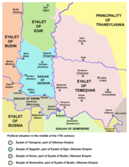
English: historic map of the Eyalet of Temeşvar, Sanjak of Sirem and Sanjak of Segedin
Српски / srpski: историјска мапа Темишварског пашалука, Сремског санџака и Сегединског санџака |
| Date | 28 décembre 2006 (date de téléversement originale) |
| Source | Travail personnel |
| Auteur | PANONIAN |
References
- Petrit Imami, Srbi i Albanci kroz vekove, Beograd, 2000.
- The Times History of Europe, Times Books, 2002.
- Istorijski atlas, Zavod za udžbenike i nastavna sredstva - Zavod za kartografiju "Geokarta", Beograd, 1999.
- Milan Tutorov, Banatska rapsodija - istorika Zrenjanina i Banata, Novi Sad, 2001.
- Peter Rokai - Zoltan Đere - Tibor Pal - Aleksandar Kasaš, Istorija Mađara, Beograd, 2002.
- Dr Dušan J. Popović, Srbi u Vojvodini, knjiga 1, Novi Sad, 1990.
- Sima M. Ćirković, Srbi među evropskim narodima, Beograd, 2004.
- Milutin Perović - Relja Novaković, Istorija za III razred gimnazije (opšti tip i društveno-jezički smer) i stručnih škola, Beograd, 1997.
- Milutin Perović - Milo Strugar, Istorija za 7. razred osnovne škole, Beograd - Novi Sad, 1993.
- Sima Ćirković, Istorija za II razred gimnazije prirodno-matematičkog smera, Beograd, 1997.
Source and licence

|
This map has been uploaded by Electionworld from en.wikipedia.org to enable the |
self made map by user:PANONIAN
Conditions d’utilisation
| Moi, propriétaire des droits d’auteur sur cette œuvre, la place dans le domaine public. Ceci s'applique dans le monde entier. Dans certains pays, ceci peut ne pas être possible ; dans ce cas : J’accorde à toute personne le droit d’utiliser cette œuvre dans n’importe quel but, sans aucune condition, sauf celles requises par la loi. |
Historique du fichier
Cliquer sur une date et heure pour voir le fichier tel qu'il était à ce moment-là.
| Date et heure | Vignette | Dimensions | Utilisateur | Commentaire | |
|---|---|---|---|---|---|
| actuel | 14 septembre 2013 à 23:04 | | 833 × 1 075 (123 kio) | PANONIAN | aesthetics |
| 5 septembre 2013 à 21:40 |  | 833 × 1 075 (127 kio) | PANONIAN | minor changes | |
| 22 mars 2009 à 23:02 |  | 837 × 1 077 (128 kio) | PANONIAN | ||
| 28 décembre 2006 à 20:59 |  | 480 × 582 (11 kio) | Electionworld | {{ew|en|PANONIAN}} historic map of the Eyalet of Temeşvar (self made) {{PD-self}} Category:Maps of the history of Romania Category:Maps of the history of Serbia Category:Maps of the history of Vojvodina |
Utilisation du fichier
Les 2 pages suivantes utilisent ce fichier :
Usage global du fichier
Les autres wikis suivants utilisent ce fichier :
- Utilisation sur az.wikipedia.org
- Utilisation sur bs.wikipedia.org
- Utilisation sur ca.wikipedia.org
- Utilisation sur de.wikipedia.org
- Utilisation sur el.wikipedia.org
- Utilisation sur en.wikipedia.org
- Utilisation sur fi.wikipedia.org
- Utilisation sur gl.wikipedia.org
- Utilisation sur he.wikipedia.org
- Utilisation sur hr.wikipedia.org
- Utilisation sur it.wikipedia.org
- Utilisation sur ja.wikipedia.org
- Utilisation sur pt.wikipedia.org
- Utilisation sur ro.wikipedia.org
- Utilisation sur ru.wikipedia.org
- Utilisation sur sh.wikipedia.org
- Utilisation sur uk.wikipedia.org