
Fichier:Claremont square, Islington (4) - geograph.org.uk - 1523975.jpg
Claremont_square,_Islington_(4)_-_geograph.org.uk_-_1523975.jpg (640 × 433 pixels, taille du fichier : 120 kio, type MIME : image/jpeg)
Ce fichier et sa description proviennent de Wikimedia Commons.
_-_geograph.org.uk_-_1523975.jpg?uselang=fr)
Description
| Description |
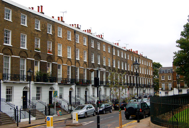
English: Claremont square, Islington (4) Looking southwest at the south side of Claremont Square, Islington. The square was developed in the 1820s around the Upper Pond of the New River Company.
The New River is a man-made water channel which carried drinking water for 20 miles to London from the River Lee and Amwell Springs in Hertfordshire. It opened in 1613 and fed reservoirs in Islington. One of these, known as the Upper Pond, was built in 1709 beside Pentonville Road. The reservoir in Claremont Square was covered and turfed in 1852 when open areas of standing water in London were prohibited by law. The reservoir is still in use by Thames Water. The semi-improved grassland on the top and sides of the reservoir supports a wide diversity of wild flowers and is a preserved habitat with restricted access. In this photo, the bank of the reservoir is just visible on the right of the picture. See also [1] and [2] . |
| Date | |
| Source | From geograph.org.uk |
| Auteur | Andy F |
| Attribution (imposé par la licence) | Andy F / Claremont square, Islington (4) / |
| Lieu de la prise de vue | | Voir cet endroit et d’autres images sur : OpenStreetMap |
|---|
_-_geograph.org.uk_-_1523975.jpg¶ms=051.531240_N_-000.109000_E_globe:Earth_type:camera_source:geograph-osgb36(TQ31268306)_heading:225.00&language=fr)
| Position de l'objet | | Voir cet endroit et d’autres images sur : OpenStreetMap |
|---|
_-_geograph.org.uk_-_1523975.jpg¶ms=051.531070_N_-000.109600_E_globe:Earth_class:object_type:object_source:geograph-osgb36(TQ31228304)_heading:225.00&language=fr)
Conditions d’utilisation

|
Cette image provient de la collection du projet Geograph British Isles. Pour obtenir les coordonnées du photographe, veuillez consulter cette page de description de l'image sur le site du projet. Les droits d'auteurs sur cette image sont détenus par Andy F ; l'image est placée sous une licence Creative Commons avec mention de paternité et partage à l'identique (CC-By-SA) en version 2.0.
|
- Vous êtes libre :
- de partager – de copier, distribuer et transmettre cette œuvre
- d’adapter – de modifier cette œuvre
- Sous les conditions suivantes :
- paternité – Vous devez donner les informations appropriées concernant l'auteur, fournir un lien vers la licence et indiquer si des modifications ont été faites. Vous pouvez faire cela par tout moyen raisonnable, mais en aucune façon suggérant que l’auteur vous soutient ou approuve l’utilisation que vous en faites.
- partage à l’identique – Si vous modifiez, transformez, ou vous basez sur cette œuvre, vous devez distribuer votre contribution sous la même licence ou une licence compatible avec celle de l’original.
Historique du fichier
Cliquer sur une date et heure pour voir le fichier tel qu'il était à ce moment-là.
| Date et heure | Vignette | Dimensions | Utilisateur | Commentaire | |
|---|---|---|---|---|---|
| actuel | 3 mars 2011 à 04:53 | | 640 × 433 (120 kio) | GeographBot | == {{int:filedesc}} == {{Information |description={{en|1=Claremont square, Islington (4) Looking southwest at the south side of Claremont Square, Islington. The square was developed in the 1820s around the Upper Pond of the New River Company. The New R |
Utilisation du fichier
Les 2 pages suivantes utilisent ce fichier :
Usage global du fichier
Les autres wikis suivants utilisent ce fichier :
- Utilisation sur ar.wikipedia.org
- Utilisation sur arz.wikipedia.org
- Utilisation sur de.wikipedia.org
- Utilisation sur ja.wikipedia.org
- Utilisation sur pl.wikipedia.org
- Utilisation sur www.wikidata.org
_-_geograph.org.uk_-_1523975.jpg)