
Fichier:Chancellorsville May3b.png

Taille de cet aperçu : 800 × 533 pixels. Autres résolutions : 320 × 213 pixels | 640 × 427 pixels | 1 024 × 683 pixels | 1 280 × 854 pixels | 2 560 × 1 707 pixels | 6 300 × 4 201 pixels.
Fichier d’origine (6 300 × 4 201 pixels, taille du fichier : 8,71 Mio, type MIME : image/png)
Ce fichier et sa description proviennent de Wikimedia Commons.
| Description |
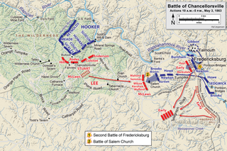
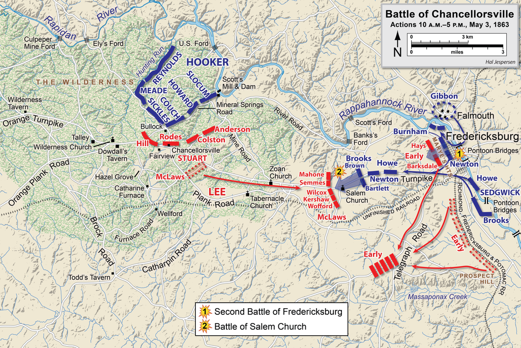
English: Map of a portion (May 3, 10am-5pm) of the battle of Chancellorsville of the American Civil War. This map partially replaces the map entitled Chancellorsville May3.png.
Drawn in Adobe Illustrator CS6 by Hal Jespersen. Graphic source file is available at http://www.cwmaps.com Ce fichier est disponible selon les termes de la licence Creative Commons Attribution 3.0 Non transposée. Attribution: Map by Hal Jespersen, www.cwmaps.com
|
| Date | |
| Source | Travail personnel |
| Auteur | Hlj |
Historique du fichier
Cliquer sur une date et heure pour voir le fichier tel qu'il était à ce moment-là.
| Date et heure | Vignette | Dimensions | Utilisateur | Commentaire | |
|---|---|---|---|---|---|
| actuel | 14 mars 2023 à 20:15 | | 6 300 × 4 201 (8,71 Mio) | Hlj | improved graphics |
| 30 décembre 2012 à 19:52 |  | 2 500 × 1 822 (1,4 Mio) | Hlj | Corrected spelling error, made minor graphic improvements | |
| 4 juin 2011 à 00:17 |  | 2 500 × 1 822 (1,34 Mio) | Hlj | Improved the accuracy of the terrain and some landmarks. Same license. | |
| 27 mars 2011 à 21:33 |  | 2 500 × 1 822 (1,3 Mio) | Hlj | Update to graphical style of rivers and roads. Same license. | |
| 28 janvier 2011 à 00:01 |  | 2 500 × 1 822 (1,01 Mio) | Hlj | Minor updates to feature labeling and unit positions and actions. {{cc-by-3.0|Map by Hal Jespersen, www.posix.com/CW}} | |
| 28 novembre 2010 à 02:16 |  | 2 500 × 1 822 (1 Mio) | Hlj | {{Information |Description={{en|1=Map of a portion (May 3, 10am-5pm) of the battle of Chancellorsville of the American Civil War. This map partially replaces the map entitled Chancellorsville May3.png. Drawn in Adobe Illustrator CS5 by Hal Jespersen. |
Utilisation du fichier
Les 3 pages suivantes utilisent ce fichier :
Usage global du fichier
Les autres wikis suivants utilisent ce fichier :
- Utilisation sur bg.wikipedia.org
- Utilisation sur en.wikipedia.org
- Utilisation sur es.wikipedia.org
- Utilisation sur it.wikipedia.org
- Utilisation sur ms.wikipedia.org
- Utilisation sur pt.wikipedia.org
- Utilisation sur ro.wikipedia.org
- Utilisation sur ru.wikipedia.org