
Fichier:Castles old and new - geograph.org.uk - 163364.jpg
Taille de cet aperçu : 450 × 600 pixels. Autres résolutions : 180 × 240 pixels | 480 × 640 pixels.
Fichier d’origine (480 × 640 pixels, taille du fichier : 101 kio, type MIME : image/jpeg)
Ce fichier et sa description proviennent de Wikimedia Commons.
Description
| Description |
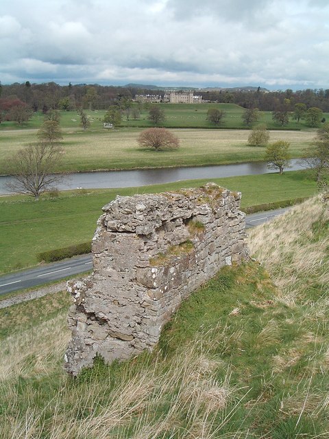
English: Castles old and new. High on its earthworks on a narrow isthmus between the Tweed and Teviot rivers, Roxburgh Castle (foreground) had strong claims in medieval times to impregnability. Not so! The castle changed hands between the Scots and English no fewer than 10 times in the border wars of the 15th and 16th centuries. Now only a few walls remain of this sometime seat of the Scottish king David 1. Across the Tweed lies elegant, Georgian, Floors Castle, seat of the Innes Kers, Dukes of Roxburghe. |
| Date | |
| Source | From geograph.org.uk |
| Auteur | Steve Kent |
| Attribution (imposé par la licence) | Steve Kent / Castles old and new / |
| Position de l'objet | | Voir cet endroit et d’autres images sur : OpenStreetMap |
|---|
_&language=fr)
Conditions d’utilisation

|
Cette image provient de la collection du projet Geograph British Isles. Pour obtenir les coordonnées du photographe, veuillez consulter cette page de description de l'image sur le site du projet. Les droits d'auteurs sur cette image sont détenus par Steve Kent ; l'image est placée sous une licence Creative Commons avec mention de paternité et partage à l'identique (CC-By-SA) en version 2.0.
|
Ce fichier est disponible selon les termes de la licence Creative Commons Attribution – Partage dans les Mêmes Conditions 2.0 Générique
Attribution: Steve Kent
- Vous êtes libre :
- de partager – de copier, distribuer et transmettre cette œuvre
- d’adapter – de modifier cette œuvre
- Sous les conditions suivantes :
- paternité – Vous devez donner les informations appropriées concernant l'auteur, fournir un lien vers la licence et indiquer si des modifications ont été faites. Vous pouvez faire cela par tout moyen raisonnable, mais en aucune façon suggérant que l’auteur vous soutient ou approuve l’utilisation que vous en faites.
- partage à l’identique – Si vous modifiez, transformez, ou vous basez sur cette œuvre, vous devez distribuer votre contribution sous la même licence ou une licence compatible avec celle de l’original.
Historique du fichier
Cliquer sur une date et heure pour voir le fichier tel qu'il était à ce moment-là.
| Date et heure | Vignette | Dimensions | Utilisateur | Commentaire | |
|---|---|---|---|---|---|
| actuel | 31 janvier 2010 à 10:01 | | 480 × 640 (101 kio) | GeographBot | == {{int:filedesc}} == {{Information |description={{en|1=Castles old and new. High on its earthworks on a narrow isthmus between the Tweed and Teviot rivers, Roxburgh Castle (foreground) had strong claims in medieval times to impregnability. Not so! The c |
Utilisation du fichier
Les 4 pages suivantes utilisent ce fichier :
Usage global du fichier
Les autres wikis suivants utilisent ce fichier :
- Utilisation sur arz.wikipedia.org
- Utilisation sur ceb.wikipedia.org
- Utilisation sur de.wikipedia.org
- Utilisation sur en.wikipedia.org
- Utilisation sur en.wikivoyage.org
- Utilisation sur eu.wikipedia.org
- Utilisation sur fa.wikipedia.org
- Utilisation sur hy.wikipedia.org
- Utilisation sur it.wikipedia.org
- Utilisation sur ko.wikipedia.org
- Utilisation sur la.wikipedia.org
- Utilisation sur nn.wikipedia.org
- Utilisation sur no.wikipedia.org
- Utilisation sur pt.wikipedia.org
- Utilisation sur uk.wikipedia.org
- Utilisation sur www.wikidata.org