
Fichier:Browns Valley flood 07.jpg

Taille de cet aperçu : 800 × 600 pixels. Autres résolutions : 320 × 240 pixels | 640 × 480 pixels | 1 024 × 768 pixels | 1 280 × 960 pixels | 2 400 × 1 800 pixels.
Fichier d’origine (2 400 × 1 800 pixels, taille du fichier : 609 kio, type MIME : image/jpeg)
Ce fichier et sa description proviennent de Wikimedia Commons.
Description
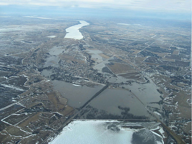
| Description | Aerial photograph showing the Traverse Gap in Minnesota and South Dakota and flooding at Browns Valley, Minnesota, from ice-covered Lake Traverse (bottom of frame), south to Big Stone Lake (top of image). Interbasin flooding is shown: The Little Minnesota River, which originates in the Mississippi watershed, enters the Traverse Gap from the west (right) and flows south to Big Stone Lake, is flooding the gap and Browns Valley (center); at the lower right floodwaters are crossing the continental divide into Lake Traverse in the watershed of Hudson Bay. |
| Date | |
| Source | JOR Engineering, Inc. |
| Auteur | JOR Engineering, Inc. |
| Autorisation (Réutilisation de ce fichier) |
"I agree to publish/allow publication of that work under the free license known as the 'GNU Free Documentation License'" . . . |
Conditions d’utilisation

|
Vous avez la permission de copier, distribuer et modifier ce document selon les termes de la GNU Free Documentation License version 1.2 ou toute version ultérieure publiée par la Free Software Foundation, sans sections inaltérables, sans texte de première page de couverture et sans texte de dernière page de couverture. Un exemplaire de la licence est inclus dans la section intitulée GNU Free Documentation License. |
| Ce fichier est disponible selon les termes de la licence Creative Commons Attribution – Partage dans les Mêmes Conditions 3.0 (non transposée). | ||
| ||
| Ce bandeau de licence a été ajouté à ce fichier dans le cadre de la procédure de mise à jour des licences des images sous GFDL. |
Historique du fichier
Cliquer sur une date et heure pour voir le fichier tel qu'il était à ce moment-là.
| Date et heure | Vignette | Dimensions | Utilisateur | Commentaire | |
|---|---|---|---|---|---|
| actuel | 21 septembre 2010 à 09:06 | | 2 400 × 1 800 (609 kio) | Sreejithk2000 | Removed watermark |
| 10 mai 2007 à 22:17 |  | 2 400 × 1 800 (404 kio) | Kablammo | {{Information |Description=Aerial photograph showing the Traverse Gap in Minnesota and South Dakota and flooding at Browns Valley, Minnesota, from Lake Traverse (bottom of frame) south to Big Stone Lake (top of image.) Interbasin flooding is shown: The L |
Utilisation du fichier
Les 2 pages suivantes utilisent ce fichier :
Usage global du fichier
Les autres wikis suivants utilisent ce fichier :
- Utilisation sur arz.wikipedia.org
- Utilisation sur da.wikipedia.org
- Utilisation sur de.wikipedia.org
- Utilisation sur en.wikipedia.org
- Utilisation sur es.wikipedia.org
- Utilisation sur pt.wikipedia.org
- Utilisation sur sv.wikipedia.org
- Utilisation sur www.wikidata.org