
Fichier:Bevölkerungsentwicklung Rhinow.pdf

Taille de cet aperçu JPG pour ce fichier PDF : 800 × 566 pixels. Autres résolutions : 320 × 226 pixels | 640 × 453 pixels | 1 024 × 724 pixels | 1 280 × 905 pixels | 1 752 × 1 239 pixels.
Fichier d’origine (1 752 × 1 239 pixels, taille du fichier : 65 kio, type MIME : application/pdf)
Ce fichier et sa description proviennent de Wikimedia Commons.
Description
| Description |
Deutsch: Bevölkerungsentwicklung in den heutigen Grenzen von Rhinow , Landkreis Havelland, Land Brandenburg, Deutschland
Blaue Linie: Bevölkerung -- Punktierte Linie: Vergleich mit der Entwicklung Brandenburgs Grauer Hintergrund: Zeit der Nazi-Herrschaft -- Roter Hintergrund: DDR-Zeit English: Population development within the current boundaries of Rhinow, Havelland district, Brandenburg state, Germany
Blue line: Population -- Dotted line: Comparison to population development of Brandenburg state Grey background: Time of nazi rule -- Red background: Time of communist rule Español: Desarrollo de la población en los actuales límites de Rhinow, distrito de Havelland, estado de Brandenburg, Alemania
Línea azul: Habitantes -- Línea de puntos: Comparación con el desarrollo de Brandenburgo Fondo gris: Período del gobierno nazi -- Fondo Rojo: Época communista Français : Développement de la population dans les limites actuelles de Rhinow, arrondissement de Havelland, Land de Brandebourg, Allemagne
Ligne bleue: Population -- Ligne pointillé: Comparaison avec le développement de Brandebourg Fond gris: Période du régime nazie -- Fond rouge: Période du régime communiste Italiano: Sviluppo della popolazione entro gli attuali confini de Rhinow, circondario de Havelland, stato federato de Brandeburgo, Germania
Linea Blu: Popolazione -- Linea puntata: Confronto dello sviluppo della popolazione dello stato del Brandenburgo Sfondo grigio: Ai tempi del governo nazista -- Sfondo rosso: Al tempo del governo comunista Nederlands: Ontwikkeling van de bevolking binnen de huidige grenzen van Rhinow, landkreis Havelland, deelstaat Brandenburg, Duitsland
Blauwe lijn: Bevolking -- Stippellijn: Vergelijking van de ontwikkeling van de bevolking van de deelstaat Brandenburg Grijze achtergrond: tijdens de nazi-regering -- Rode achtergrond: tijdens de communistische regering Polski: Rozwój ludności w obecnych granicach dla Rhinow, powiat Havelland, kraj Brandenburgia, Niemcy
Niebieska linia: Populacja -- Linia przerywana: Porównanie z rozwoju Brandenburgii Szare tło: Okres hitlerowców -- Czerwone tło: Okres rządów komunistycznych Svenska: Befolkningsutvecklingen i de nuvarande gränserna för Rhinow, landkreis Havelland, delstaten Brandenburg, Tyskland Blå linje: Befolkning -- Prickade linjen: Jämförelse med utvecklingen av Brandenburg Grå bakgrund: Period av Nazi styre -- Röd bakgrund: Period av kommunistiskt styre |
| Date | entre le 28 décembre 2013 et le 8 juillet 2023 |
| Source | Travail personnel basé sur : Data sources displayed at Population Projection Brandenburg at Wikimedia Commons |
| Auteur | Hans G. Oberlack |
| Latest population data | 2020 |
| Position de l'objet | | Voir cet endroit et d’autres images sur : OpenStreetMap |
|---|
Conditions d’utilisation
Moi, en tant que détenteur des droits d’auteur sur cette œuvre, je la publie sous la licence suivante :
Ce fichier est disponible selon les termes de la licence Creative Commons Attribution – Partage dans les Mêmes Conditions 3.0 (non transposée).
- Vous êtes libre :
- de partager – de copier, distribuer et transmettre cette œuvre
- d’adapter – de modifier cette œuvre
- Sous les conditions suivantes :
- paternité – Vous devez donner les informations appropriées concernant l'auteur, fournir un lien vers la licence et indiquer si des modifications ont été faites. Vous pouvez faire cela par tout moyen raisonnable, mais en aucune façon suggérant que l’auteur vous soutient ou approuve l’utilisation que vous en faites.
- partage à l’identique – Si vous modifiez, transformez, ou vous basez sur cette œuvre, vous devez distribuer votre contribution sous la même licence ou une licence compatible avec celle de l’original.
Historique du fichier
Cliquer sur une date et heure pour voir le fichier tel qu'il était à ce moment-là.
| Date et heure | Vignette | Dimensions | Utilisateur | Commentaire | |
|---|---|---|---|---|---|
| actuel | 8 juillet 2023 à 23:53 |  | 1 752 × 1 239 (65 kio) | Hans G. Oberlack | data till 2020 added |
| 7 février 2018 à 22:39 | 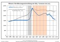 | 1 752 × 1 239 (120 kio) | Hans G. Oberlack | 2016 data added | |
| 4 janvier 2017 à 01:35 | Aucune vignette | 0 × 0 (119 kio) | Hans G. Oberlack | 2015 data added | |
| 28 décembre 2013 à 15:10 | Aucune vignette | 0 × 0 (98 kio) | Hans G. Oberlack | User created page with UploadWizard |
Utilisation du fichier
La page suivante utilise ce fichier :
Usage global du fichier
Les autres wikis suivants utilisent ce fichier :