
Fichier:Belgian Railway Line 24.png

Taille de cet aperçu : 800 × 567 pixels. Autres résolutions : 320 × 227 pixels | 640 × 453 pixels | 1 024 × 725 pixels | 1 280 × 906 pixels | 1 453 × 1 029 pixels.
Fichier d’origine (1 453 × 1 029 pixels, taille du fichier : 2,4 Mio, type MIME : image/png)
Ce fichier et sa description proviennent de Wikimedia Commons.
Description
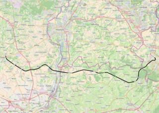
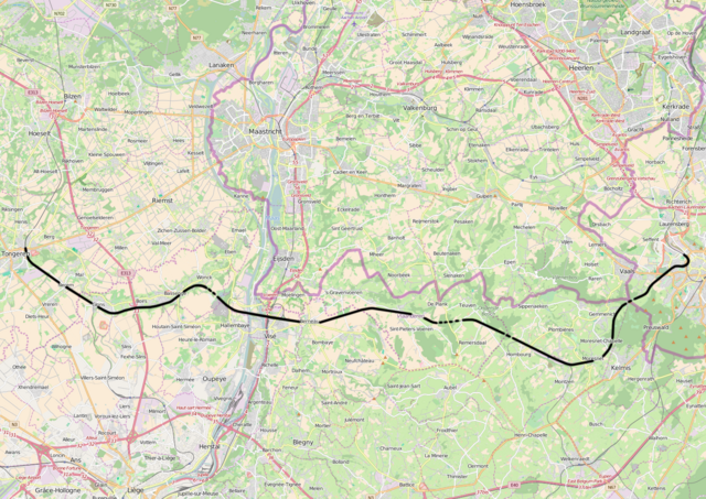
| Description | Belgian Railway Line 24, Tongeren - Aachen |
| Source | openstreetmap.org, see Relation: 59745 from the OpenStreetMap Belgium/Railways project. |
| Auteur | OpenStreetMap contributors |
| Autorisation (Réutilisation de ce fichier) |
All OpenStreetMap data and maps are Creative Commons "CC-BY-SA 2.0" licensed |
Conditions d’utilisation
Ce fichier est disponible selon les termes de la licence Creative Commons Attribution – Partage dans les Mêmes Conditions 2.0 Générique
- Vous êtes libre :
- de partager – de copier, distribuer et transmettre cette œuvre
- d’adapter – de modifier cette œuvre
- Sous les conditions suivantes :
- paternité – Vous devez donner les informations appropriées concernant l'auteur, fournir un lien vers la licence et indiquer si des modifications ont été faites. Vous pouvez faire cela par tout moyen raisonnable, mais en aucune façon suggérant que l’auteur vous soutient ou approuve l’utilisation que vous en faites.
- partage à l’identique – Si vous modifiez, transformez, ou vous basez sur cette œuvre, vous devez distribuer votre contribution sous la même licence ou une licence compatible avec celle de l’original.
Historique du fichier
Cliquer sur une date et heure pour voir le fichier tel qu'il était à ce moment-là.
| Date et heure | Vignette | Dimensions | Utilisateur | Commentaire | |
|---|---|---|---|---|---|
| actuel | 20 avril 2016 à 18:15 | | 1 453 × 1 029 (2,4 Mio) | Vunz | improved |
| 2 septembre 2010 à 17:24 |  | 1 130 × 783 (1,14 Mio) | Vunz | ||
| 30 septembre 2009 à 12:26 |  | 1 130 × 783 (1,14 Mio) | Vunz | Open Street Map spoorlijn 24 Category:Rail transport maps of Belgium | |
| 16 janvier 2009 à 23:00 |  | 520 × 390 (97 kio) | Vunz | adjusted height and width Category:Rail transport maps of Belgium Category:Public domain maps from demis.nl | |
| 4 janvier 2009 à 14:23 |  | 700 × 390 (116 kio) | Vunz | {{Information |Description={{nl|1=spoorkaart}} |Source=Own work |Author=Wiebevl |Date=4/1/9 |Permission= |other_versions= }} <!--{{ImageUpload|full}}--> Category:Rail transport maps of Belgium [[Category:Public domain maps from demis |
Utilisation du fichier
La page suivante utilise ce fichier :
Usage global du fichier
Les autres wikis suivants utilisent ce fichier :
- Utilisation sur de.wikipedia.org
- Utilisation sur nl.wikipedia.org
- Utilisation sur www.wikidata.org