
Fichier:Alps geology map en.jpg

Fichier d’origine (3 338 × 1 607 pixels, taille du fichier : 1,86 Mio, type MIME : image/jpeg)
Ce fichier et sa description proviennent de Wikimedia Commons.
source: http://en.wikipedia.org/wiki/Image:Alps_geology_map_en.jpg
Description
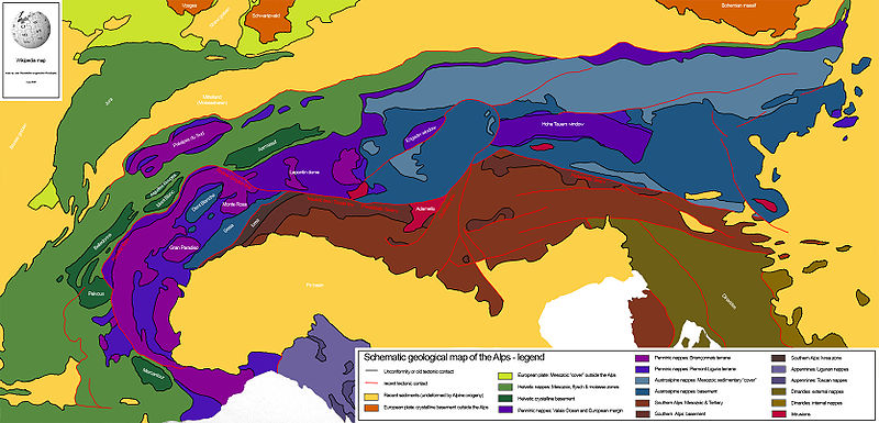
Drew this map myself.
en:User:Woodwalker
this "alps geology map" is only partly "drew by Woodwalker himself"
Woodwalker used the original "tectonic map of the alps" by stefan schmid et all and silvio lauer
https://tecto.earth.unibas.ch/research/Schmid_et_al_2004_Ecl.pdf
anyway , it is a well-done summary
14:53, 2 June 2006 (UTC)
There is an error in the name of the "Tauern Window". This is not the "Hohe Tauern" which is a mountain range in the Austrian Alps close to Salzburg rather than the "Tauern Window" which is a metamorphic window in the Alps bounded by the Katschberg Fault, SEMP fault Brenner Fault etc.. Please change the "Hohe Tauern Window" to "Tauern Window"
Conditions d’utilisation
| Moi, propriétaire des droits d’auteur sur cette œuvre, la place dans le domaine public. Ceci s'applique dans le monde entier. Dans certains pays, ceci peut ne pas être possible ; dans ce cas : J’accorde à toute personne le droit d’utiliser cette œuvre dans n’importe quel but, sans aucune condition, sauf celles requises par la loi. |
Historique du fichier
Cliquer sur une date et heure pour voir le fichier tel qu'il était à ce moment-là.
| Date et heure | Vignette | Dimensions | Utilisateur | Commentaire | |
|---|---|---|---|---|---|
| actuel | 14 juillet 2008 à 23:24 | | 3 338 × 1 607 (1,86 Mio) | Ori~ | source: http://en.wikipedia.org/wiki/Image:Alps_geology_map_en.jpg == Summary == Drew this map myself. en:User:Woodwalker 14:53, 2 June 2006 (UTC) == Licensing == {{PD-self}} |
Utilisation du fichier
La page suivante utilise ce fichier :
Usage global du fichier
Les autres wikis suivants utilisent ce fichier :
- Utilisation sur en.wikipedia.org
- Geology of the Alps
- Periadriatic Seam
- Template:Geology of the Alps
- Helvetic (geology)
- Penninic
- Austroalpine nappes
- Southern Alps (Europe)
- Aarmassif
- Dent Blanche nappe
- Hohe Tauern window
- Ivrea zone
- Sesia zone
- Bündner schist
- Valais Ocean
- Briançonnais zone
- Piemont-Liguria Ocean
- Adriatic Plate
- Giudicarie Line
- Greywacke zone
- Rhône-Simplon line
- Lepontin dome
- Molasse basin
- Penninic thrustfront
- Engadin window
- Wetterstein Formation
- Engadine Line
- Utilisation sur eu.wikipedia.org
- Utilisation sur sl.wikipedia.org