
Fichier:669px DEMBauges titrage.png
Pas de plus haute résolution disponible.
669px_DEMBauges_titrage.png (631 × 571 pixels, taille du fichier : 675 kio, type MIME : image/png)
Ce fichier et sa description proviennent de Wikimedia Commons.
Description
| Description |
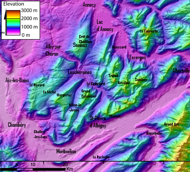
Français : DEM of the Bauges massifs (french Alps) created by Jide from the 90m pixel size SRTM dataset. The massif is located between the Bourget Lake (to the West) and the Annecy Lake (to the NE). The ENE-WSW valley to the South is the Isere valley downstrem to the West). The Cheran river cut the massif from the SE to the NW.
Modifié par Semnoz pour mettre les titres. -Semnoz 25 février 2006 à 19:34 (CET) |
| Date | 25 février 2006 (date de téléversement originale) |
| Source | Transféré de fr.wikipedia à Commons. |
| Auteur | Semnoz sur Wikipédia français |
Conditions d’utilisation
| Cette œuvre a été placée dans le domaine public par son auteur, Semnoz sur Wikipédia français. Ceci s’applique dans le monde entier. Dans certains pays, ceci peut ne pas être possible ; dans ce cas : Semnoz accorde à toute personne le droit d’utiliser cette œuvre dans n’importe quel but, sans aucune condition, sauf celles requises par la loi. |
Journal des téléversements d’origine
La page de description originale était ici. Tous les noms d'utilisateur qui suivent se rapportent à fr.wikipedia.
- 2006-02-25 18:34 Semnoz 669×599× (1003038 bytes) == Summary == DEM of the Bauges massifs (french Alps) created by Jide from the 90m pixel size SRTM dataset. The massif is located between the Bourget Lake (to the West) and the Annecy Lake (to the NE). The ENE-WSW valley to the South is the Isere valley d
Historique du fichier
Cliquer sur une date et heure pour voir le fichier tel qu'il était à ce moment-là.
| Date et heure | Vignette | Dimensions | Utilisateur | Commentaire | |
|---|---|---|---|---|---|
| actuel | 17 février 2024 à 22:57 | | 631 × 571 (675 kio) | Rémih | Cropped 6 % horizontally, 5 % vertically using CropTool with precise mode. |
| 20 septembre 2009 à 22:00 |  | 669 × 599 (980 kio) | Francofranco56 | {{Information |Description={{fr|DEM of the Bauges massifs (french Alps) created by Jide from the 90m pixel size SRTM dataset. The massif is located between the Bourget Lake (to the West) and the Annecy Lake (to the NE). The ENE-WSW valley to the South is |
Utilisation du fichier
Aucune page n’utilise ce fichier.