
Fichier:Opekiska Lock and Dam Monongahela.jpg

Taille de cet aperçu : 800 × 533 pixels. Autres résolutions : 320 × 213 pixels | 640 × 427 pixels | 1 024 × 683 pixels | 1 500 × 1 000 pixels.
Fichier d’origine (1 500 × 1 000 pixels, taille du fichier : 329 kio, type MIME : image/jpeg)
Ce fichier et sa description proviennent de Wikimedia Commons.
| Description |
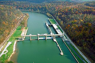
English: Opekiska Lock and Dam on the Monongahela River. The dam is located about seven miles northeast (downriver) from Fairmont, West Virginia, at river mile 115.4. The lock and dam were constructed 1961–64 by the U.S. Army Corps of Engineers to improve navigation on the Monongahela River, replacing 60-year-old locks 14 and 15. View is downriver to the northeast. |
|||
| Date | May 1, 1998 (as given on the descripton page, but the date is dubious) | |||
| Source |
U.S. Army Corps of Engineers Digital Visual Library Image page Image description page Digital Visual Library home page U.S. Army Corps of Engineers project page |
|||
| Auteur | Margaret Luzier, U.S. Army Corps of Engineers | |||
| Autorisation (Réutilisation de ce fichier) |
|
|||
| Lieu | Fairmont, West Virginia, USA |
| Lieu de la prise de vue | | Voir cet endroit et d’autres images sur : OpenStreetMap |
|---|
Historique du fichier
Cliquer sur une date et heure pour voir le fichier tel qu'il était à ce moment-là.
| Date et heure | Vignette | Dimensions | Utilisateur | Commentaire | |
|---|---|---|---|---|---|
| actuel | 24 mars 2007 à 18:37 | | 1 500 × 1 000 (329 kio) | DanMS | {{Information | Description = {{en|Opekiska Lock and Dam on the Monongahela River. The dam is located about seven miles northeast (downriver) from Fairmont, West Virginia, at river mile 115.4. The lock and dam were constructed 1961–64 by the U.S. Arm |
Utilisation du fichier
La page suivante utilise ce fichier :
Usage global du fichier
Les autres wikis suivants utilisent ce fichier :
- Utilisation sur en.wikipedia.org
- Utilisation sur es.wikipedia.org
- Utilisation sur gl.wikipedia.org
- Utilisation sur it.wikipedia.org
- Utilisation sur xmf.wikipedia.org