
Fichier:Cerros colorados res.jpg

Taille de cet aperçu : 600 × 600 pixels. Autres résolutions : 240 × 240 pixels | 480 × 480 pixels | 768 × 768 pixels | 1 024 × 1 024 pixels | 2 048 × 2 048 pixels | 5 237 × 5 237 pixels.
Fichier d’origine (5 237 × 5 237 pixels, taille du fichier : 8,8 Mio, type MIME : image/jpeg)
Ce fichier et sa description proviennent de Wikimedia Commons.
Description
| Description |
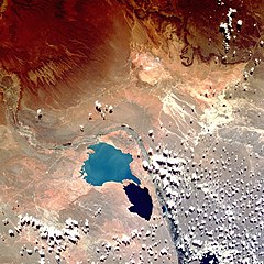
English: Shuttle image of "Cerros Colorados Complex", province of Neuquén, Argentina, March 1990
|
| Date | |
| Source | http://eol.jsc.nasa.gov/sseop/EFS/photoinfo.pl?PHOTO=STS036-80-62 |
| Auteur | Image Science & Analysis Laboratory, NASA Johnson Space Center |
| Lieu de la prise de vue | | Voir cet endroit et d’autres images sur : OpenStreetMap |
|---|
Cette image ou vidéo a été cataloguée par le Johnson Space Center de la National Aeronautics and Space Administration (NASA) des États-Unis sous Photo ID : STS036-80-62.Ce bandeau n’indique rien sur le statut de l’œuvre au regard du droit d'auteur. Un bandeau de droit d’auteur est requis. Voir Commons:À propos des licences pour plus d’informations. Autres langues :
|
Conditions d’utilisation
"The Gateway to Astronaut Photography of Earth". Image provenant du Laboratoire d'Analyse et d'Imagerie des Sciences, Centre Spatial Johnson de la NASA.
Source de la photo : STS036-80-62.
|
Historique du fichier
Cliquer sur une date et heure pour voir le fichier tel qu'il était à ce moment-là.
| Date et heure | Vignette | Dimensions | Utilisateur | Commentaire | |
|---|---|---|---|---|---|
| actuel | 7 août 2013 à 17:38 | | 5 237 × 5 237 (8,8 Mio) | Ras67 | high resolution |
| 26 octobre 2007 à 20:49 |  | 640 × 640 (180 kio) | Denniss | ||
| 15 février 2007 à 22:16 |  | 600 × 600 (103 kio) | Rosarinagazo | Shuttle image of "Cerros Colorados Complex", province of Chubut, Argentina Author: NASA http://en.wikipedia.org/wiki/Image:Cerros_colorados_res.jpg Category:Dams |
Utilisation du fichier
Les 5 pages suivantes utilisent ce fichier :
Usage global du fichier
Les autres wikis suivants utilisent ce fichier :
- Utilisation sur de.wikipedia.org
- Utilisation sur en.wikipedia.org
- Utilisation sur eo.wikipedia.org
- Utilisation sur es.wikipedia.org
- Utilisation sur gl.wikipedia.org
- Utilisation sur lt.wikipedia.org
- Utilisation sur no.wikipedia.org
- Utilisation sur uk.wikipedia.org
- Utilisation sur www.wikidata.org
- Utilisation sur zh.wikipedia.org