
Fichier:Types of offshore oil and gas structures.jpg
Pas de plus haute résolution disponible.
Types_of_offshore_oil_and_gas_structures.jpg (600 × 236 pixels, taille du fichier : 97 kio, type MIME : image/jpeg)
Ce fichier et sa description proviennent de Wikimedia Commons.
Description
| Description |
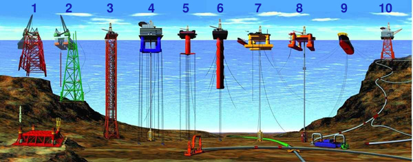
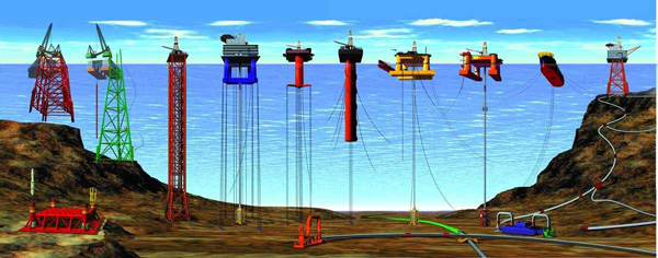
English: Types of Offshore Oil and Gas Structures
Deutsch: Arten von Öl- und Gasbohrinseln
|
| Date | Revised at 15 décembre 2008 |
| Source | |
| Auteur |
|
| Autres versions |
|

Conditions d’utilisation
Cette image est dans le domaine public car son contenu provient de la
National Oceanic and Atmospheric Administration , réalisé par un employé dans le cadre de ses activités professionnelles.
|
Historique du fichier
Cliquer sur une date et heure pour voir le fichier tel qu'il était à ce moment-là.
| Date et heure | Vignette | Dimensions | Utilisateur | Commentaire | |
|---|---|---|---|---|---|
| actuel | 25 octobre 2013 à 21:44 | 600 × 236 (97 kio) | Jaybear | Numbers added; | |
| 23 mai 2010 à 19:56 | 600 × 236 (72 kio) | Emerson7 | {{Information |Description = Types of offshore oil and gas structures incude: 1, 2) conventional fixed platforms (deepest: Shell’s Bullwinkle in 1991 at 412 m/1,353 ft GOM); 3) compliant tower (deepest: ChevronTexaco’s Petronius in 1998 at 534 m / |
Utilisation du fichier
La page suivante utilise ce fichier :
Usage global du fichier
Les autres wikis suivants utilisent ce fichier :
- Utilisation sur ar.wikipedia.org
- Utilisation sur cs.wikipedia.org
- Utilisation sur de.wikipedia.org
- Utilisation sur en.wikipedia.org
- Utilisation sur eo.wikipedia.org
- Utilisation sur es.wikipedia.org
- Utilisation sur fy.wikipedia.org
- Utilisation sur gl.wikipedia.org
- Utilisation sur he.wikipedia.org
- Utilisation sur it.wikipedia.org
- Utilisation sur ja.wikipedia.org
- Utilisation sur nl.wikipedia.org
- Utilisation sur pl.wikipedia.org
- Utilisation sur pt.wikipedia.org
- Utilisation sur ru.wikipedia.org
- Utilisation sur sh.wikipedia.org
- Utilisation sur sk.wikipedia.org
- Utilisation sur sl.wikipedia.org
- Utilisation sur tr.wikipedia.org
- Utilisation sur uk.wikipedia.org
- Utilisation sur vi.wikipedia.org
- Utilisation sur zh-yue.wikipedia.org
- Utilisation sur zh.wikipedia.org