
Fichier:Ryknild street.jpg
Pas de plus haute résolution disponible.
Ryknild_street.jpg (640 × 480 pixels, taille du fichier : 175 kio, type MIME : image/jpeg)
Ce fichier et sa description proviennent de Wikimedia Commons.
| Description |
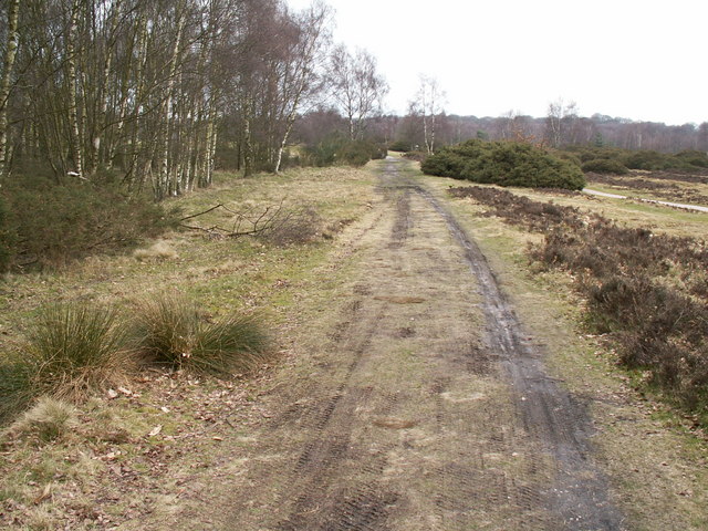
Ryknild Street Roman Road, Sutton Park. Ryknild Street Roman Road, Sutton Park Looking north east. The 1.5 mile section of the Roman road that runs through Sutton Park is one of the best preserved in the country, clearly showing the constructional features typical of roads in this part of the empire. This section of road linked the forts at Metcley (Birmingham) and Wall near Lichfield. |
| Date | |
| Source | From geograph.org.uk |
| Auteur | Phil Champion |
| Autorisation (Réutilisation de ce fichier) |
Creative Commons Attribution Share-alike license 2.0 |
| Lieu de la prise de vue | | Voir cet endroit et d’autres images sur : OpenStreetMap |
|---|

|
Cette image provient de la collection du projet Geograph British Isles. Pour obtenir les coordonnées du photographe, veuillez consulter cette page de description de l'image sur le site du projet. Les droits d'auteurs sur cette image sont détenus par Phil Champion ; l'image est placée sous une licence Creative Commons avec mention de paternité et partage à l'identique (CC-By-SA) en version 2.0.
|
Ce fichier est disponible selon les termes de la licence Creative Commons Attribution – Partage dans les Mêmes Conditions 2.0 Générique
Attribution: Phil Champion
- Vous êtes libre :
- de partager – de copier, distribuer et transmettre cette œuvre
- d’adapter – de modifier cette œuvre
- Sous les conditions suivantes :
- paternité – Vous devez donner les informations appropriées concernant l'auteur, fournir un lien vers la licence et indiquer si des modifications ont été faites. Vous pouvez faire cela par tout moyen raisonnable, mais en aucune façon suggérant que l’auteur vous soutient ou approuve l’utilisation que vous en faites.
- partage à l’identique – Si vous modifiez, transformez, ou vous basez sur cette œuvre, vous devez distribuer votre contribution sous la même licence ou une licence compatible avec celle de l’original.
Historique du fichier
Cliquer sur une date et heure pour voir le fichier tel qu'il était à ce moment-là.
| Date et heure | Vignette | Dimensions | Utilisateur | Commentaire | |
|---|---|---|---|---|---|
| actuel | 31 décembre 2008 à 15:53 | | 640 × 480 (175 kio) | Victuallers | {{Information |Description=Ryknild Street Roman Road, Sutton Park. Ryknild Street Roman Road, Sutton Park Looking north east. The 1.5 mile section of the Roman road that runs through Sutton Park is one of the best preserved in the co |
Utilisation du fichier
La page suivante utilise ce fichier :
Usage global du fichier
Les autres wikis suivants utilisent ce fichier :
- Utilisation sur be-tarask.wikipedia.org
- Utilisation sur ca.wikipedia.org
- Utilisation sur cs.wikipedia.org
- Utilisation sur en.wikipedia.org
- Utilisation sur es.wikipedia.org
- Utilisation sur fi.wikipedia.org
- Utilisation sur it.wikipedia.org
- Utilisation sur la.wikipedia.org
- Utilisation sur no.wikipedia.org
- Utilisation sur pt.wikipedia.org
- Utilisation sur ru.wikipedia.org
- Utilisation sur simple.wikipedia.org
- Utilisation sur www.wikidata.org