
Fichier:Ontario QEW map.svg

Taille de cet aperçu PNG pour ce fichier SVG : 512 × 395 pixels. Autres résolutions : 311 × 240 pixels | 622 × 480 pixels | 996 × 768 pixels | 1 280 × 988 pixels | 2 560 × 1 975 pixels.
Fichier d’origine (Fichier SVG, nominalement de 512 × 395 pixels, taille : 359 kio)
Ce fichier et sa description proviennent de Wikimedia Commons.
Description
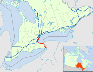
| Description | A map of Ontario's 400-series freeways, with Provincial Highway QEW in orange. |
| Date | (UTC) |
| Source | modified from File:Canada_Ontario_location_map.svg |
| Auteur | Floydian (talk) |
Conditions d’utilisation
Ce fichier est disponible selon les termes de la licence Creative Commons Attribution – Partage dans les Mêmes Conditions 3.0 (non transposée).
- Vous êtes libre :
- de partager – de copier, distribuer et transmettre cette œuvre
- d’adapter – de modifier cette œuvre
- Sous les conditions suivantes :
- paternité – Vous devez donner les informations appropriées concernant l'auteur, fournir un lien vers la licence et indiquer si des modifications ont été faites. Vous pouvez faire cela par tout moyen raisonnable, mais en aucune façon suggérant que l’auteur vous soutient ou approuve l’utilisation que vous en faites.
- partage à l’identique – Si vous modifiez, transformez, ou vous basez sur cette œuvre, vous devez distribuer votre contribution sous la même licence ou une licence compatible avec celle de l’original.
Historique du fichier
Cliquer sur une date et heure pour voir le fichier tel qu'il était à ce moment-là.
| Date et heure | Vignette | Dimensions | Utilisateur | Commentaire | |
|---|---|---|---|---|---|
| actuel | 24 février 2021 à 01:45 | | 512 × 395 (359 kio) | Floydian | update for 2021 |
| 23 février 2021 à 20:44 |  | 512 × 391 (213 kio) | Floydian | Would be really nice to click on the thumbnail and preview it before I upload | |
| 23 février 2021 à 20:43 |  | 512 × 391 (213 kio) | Floydian | make linestrokes thicker | |
| 23 février 2021 à 20:38 |  | 512 × 391 (213 kio) | Floydian | update for 2021 | |
| 26 mai 2010 à 00:25 |  | 900 × 750 (576 kio) | Floydian | ||
| 3 mars 2010 à 19:38 |  | 1 060 × 810 (653 kio) | Floydian | {{Information |Description=A map of Ontario's 400-series freeways, with Provincial Highway QEW in orange. |Source=modified from File:Canada_Ontario_location_map.svg |Date=~~~~~ |Author=~~~ |Permission= |other_versions= }} [[Category:Maps of Ontario H |
Utilisation du fichier
La page suivante utilise ce fichier :
Usage global du fichier
Les autres wikis suivants utilisent ce fichier :
- Utilisation sur de.wikipedia.org
- Utilisation sur en.wikipedia.org
- Utilisation sur fa.wikipedia.org
- Utilisation sur it.wikipedia.org
- Utilisation sur pl.wikipedia.org
- Utilisation sur www.wikidata.org
- Utilisation sur zh.wikipedia.org