
Fichier:NepalAchhamDistrictmap.png

Taille de cet aperçu : 424 × 600 pixels. Autres résolutions : 169 × 240 pixels | 339 × 480 pixels | 543 × 768 pixels | 723 × 1 024 pixels | 2 479 × 3 508 pixels.
Fichier d’origine (2 479 × 3 508 pixels, taille du fichier : 339 kio, type MIME : image/png)
Ce fichier et sa description proviennent de Wikimedia Commons.
| Description |
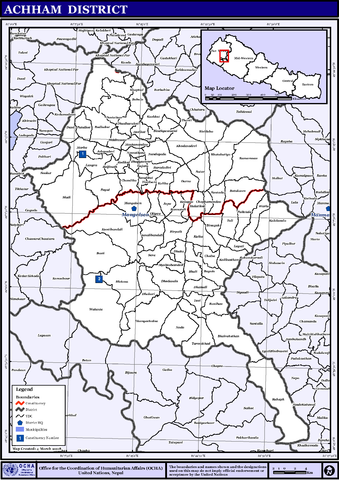
English: Map displaying Village Development Committees in Achham District, Nepal |
|||
| Date | ||||
| Source | http://www.un.org.np/maps/district-maps/far-western/Achham.pdf | |||
| Auteur | United Nations | |||
| Autorisation (Réutilisation de ce fichier) |
|

Historique du fichier
Cliquer sur une date et heure pour voir le fichier tel qu'il était à ce moment-là.
| Date et heure | Vignette | Dimensions | Utilisateur | Commentaire | |
|---|---|---|---|---|---|
| actuel | 6 novembre 2008 à 03:24 | | 2 479 × 3 508 (339 kio) | Sadalmelik | {{Information |Description={{en|1=Map displaying Village Development Committees in Achham District, Nepal}} |Source=http://www.un.org.np/maps/district-maps/far-western/Achham.pdf |Date=March 4, 2008 |Author=United Nations |Permission={{PD-UN}} |other_ |
Utilisation du fichier
Aucune page n’utilise ce fichier.
Usage global du fichier
Les autres wikis suivants utilisent ce fichier :
- Utilisation sur bpy.wikipedia.org
- Utilisation sur de.wikipedia.org
- Utilisation sur en.wikipedia.org
- Utilisation sur fi.wikipedia.org
- Utilisation sur hif.wikipedia.org
- Utilisation sur hi.wikipedia.org
- ग्राम विकास समिति
- साँचा:अछाम जिला
- ऋषिदह
- कालागाउँ
- कालिका, अछाम
- कालिकास्थान, अछाम
- कालेगाँडा
- कुइका
- कुशकोट
- खप्तड
- गजरा गाँव
- घोडासैण
- चाँफामाण्डौ
- चाल्सा
- छतरा
- जनालीकोट
- टिमिलसैन
- ठांटी
- ढकारी
- ढाकु
- ढुंगाचाल्ना
- ढुडारुकोट
- तडीगैरा
- तुर्माखाँद
- तोली, अछाम
- तोसी
- दर्ना
- दुनी
- देविस्थान
- धमाली
- नंदेगडा
- नाडा
- पाइल
- पातलकोट
- पुलेतोला
- बाबला
- बयाला
- बर्दादेबी
- बलाँता
- बस्ती, अछाम
- बाटुलासैन
- बान्नातोली
- बारला
- बिनायक
- बिन्ध्यावासीनी, अछाम
Voir davantage sur l’utilisation globale de ce fichier.