
Fichier:Livingston-Island-Map-2010-15.png
Taille de cet aperçu : 799 × 600 pixels. Autres résolutions : 320 × 240 pixels | 640 × 480 pixels | 1 023 × 768 pixels | 1 280 × 961 pixels | 2 560 × 1 922 pixels | 5 337 × 4 006 pixels.
Fichier d’origine (5 337 × 4 006 pixels, taille du fichier : 9,65 Mio, type MIME : image/png)
Ce fichier et sa description proviennent de Wikimedia Commons.
Description
| Description |
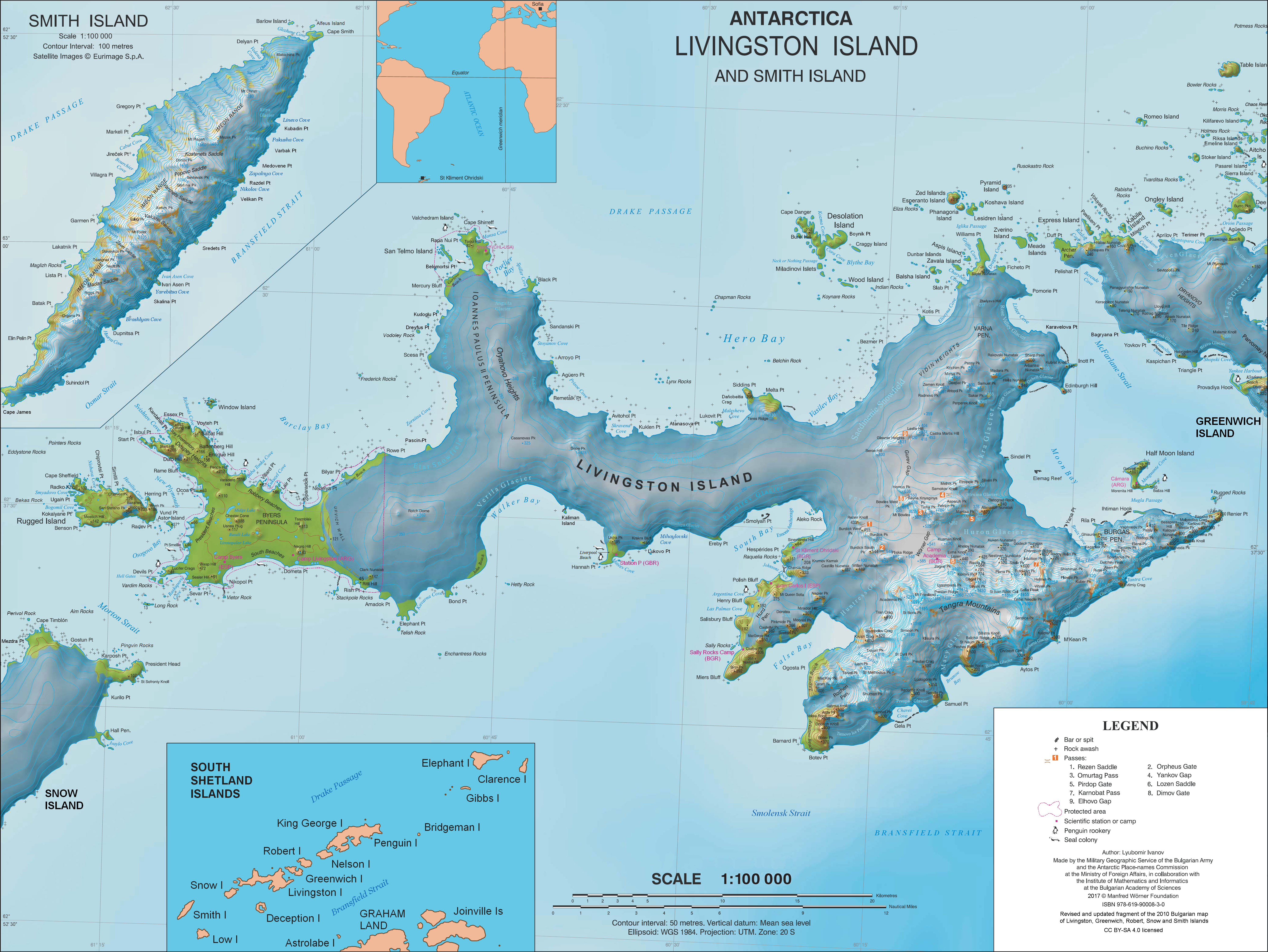
English: L.L. Ivanov. Antarctica: Livingston Island and Smith Island. Scale 1:100000 topographic map. Manfred Wörner Foundation, 2017. ISBN 978-619-90008-3-0 |
| Date | |
| Source | Travail personnel |
| Auteur | Apcbg |
| Autorisation (Réutilisation de ce fichier) |
Published by the Manfred Wörner Foundation under the Creative Commons Attribution ShareAlike 4.0 license. |
| Autres versions | File:Livingston-Island-Map-2010.jpg, an earlier version |
Conditions d’utilisation
Moi, en tant que détenteur des droits d’auteur sur cette œuvre, je la publie sous la licence suivante :
Ce fichier est sous la licence Creative Commons Attribution – Partage dans les Mêmes Conditions 4.0 International.
- Vous êtes libre :
- de partager – de copier, distribuer et transmettre cette œuvre
- d’adapter – de modifier cette œuvre
- Sous les conditions suivantes :
- paternité – Vous devez donner les informations appropriées concernant l'auteur, fournir un lien vers la licence et indiquer si des modifications ont été faites. Vous pouvez faire cela par tout moyen raisonnable, mais en aucune façon suggérant que l’auteur vous soutient ou approuve l’utilisation que vous en faites.
- partage à l’identique – Si vous modifiez, transformez, ou vous basez sur cette œuvre, vous devez distribuer votre contribution sous la même licence ou une licence compatible avec celle de l’original.
Historique du fichier
Cliquer sur une date et heure pour voir le fichier tel qu'il était à ce moment-là.
| Date et heure | Vignette | Dimensions | Utilisateur | Commentaire | |
|---|---|---|---|---|---|
| actuel | 2 avril 2021 à 12:28 | | 5 337 × 4 006 (9,65 Mio) | Apcbg | update |
| 27 juin 2019 à 15:21 |  | 5 337 × 4 006 (9,65 Mio) | Apcbg | minor update | |
| 23 mai 2019 à 14:21 |  | 5 337 × 4 006 (9,65 Mio) | Apcbg | update | |
| 19 mars 2019 à 10:22 |  | 5 337 × 4 006 (9,65 Mio) | Apcbg | minor update | |
| 9 février 2019 à 23:14 |  | 5 337 × 4 006 (9,66 Mio) | Apcbg | Update | |
| 5 février 2019 à 17:35 |  | 5 337 × 4 006 (9,66 Mio) | Apcbg | Minor | |
| 2 février 2019 à 21:20 |  | 5 337 × 4 006 (9,66 Mio) | Apcbg | Update | |
| 9 août 2018 à 08:44 |  | 5 337 × 4 006 (9,66 Mio) | Apcbg | Update | |
| 8 août 2018 à 08:17 |  | 5 337 × 4 006 (9,66 Mio) | Apcbg | Update | |
| 31 mars 2017 à 13:38 |  | 5 337 × 4 006 (10,92 Mio) | Apcbg | Updated topography and toponymy |
Utilisation du fichier
Les 5 pages suivantes utilisent ce fichier :
Usage global du fichier
Les autres wikis suivants utilisent ce fichier :
- Utilisation sur ar.wikipedia.org
- Utilisation sur ast.wikipedia.org
- Utilisation sur az.wikipedia.org
- Utilisation sur bg.wikipedia.org
- Свети Климент Охридски (база)
- Ливингстън (остров)
- Тангра (планина)
- Монтана (връх)
- Академия (връх)
- Айтос (нос)
- Авитохол (нос)
- Цариград (връх)
- Лясковец (връх)
- Фрисланд (връх)
- Видински възвишения
- Куцото куче
- Свети Борис (връх)
- Симеон (връх)
- Варна (полуостров)
- Свети Иван Рилски (рид)
- Потребител:Dafosaddikk/Скала Белчин
- Скала Белчин
- Utilisation sur ca.wikipedia.org
- Utilisation sur ceb.wikipedia.org
- Utilisation sur de.wikipedia.org
- Livingston-Insel
- Table Island (Südliche Shetlandinseln)
- Barclay Bay
- Kap Shirreff
- Johannes-Paul-II.-Halbinsel
- Hero Bay
- Desolation Island (Südliche Shetlandinseln)
- Burdick Peak
- Black Point (Livingston-Insel)
- Blythe Bay
- Hemus Peak
- Leslie Hill (Livingston-Insel)
- Brunow Bay
- Bravo-Gletscher
- McFarlane Strait
- Renier Point
- Burdick South Peak
- Burdick West Peak
- Willan-Nunatak
- Plíska Ridge
- Rotch Dome
- Cora Cove
- Craggy Island (Südliche Shetlandinseln)
Voir davantage sur l’utilisation globale de ce fichier.