
Fichier:Inini.png

Taille de cet aperçu : 523 × 600 pixels. Autres résolutions : 209 × 240 pixels | 419 × 480 pixels | 670 × 768 pixels | 893 × 1 024 pixels | 1 884 × 2 160 pixels.
Fichier d’origine (1 884 × 2 160 pixels, taille du fichier : 71 kio, type MIME : image/png)
Ce fichier et sa description proviennent de Wikimedia Commons.
Description
| Description |
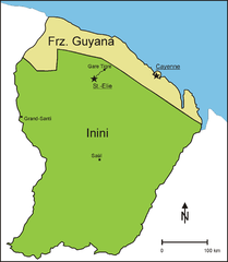
English: Division of French Guiana from 1930 to 1946 into a coastal strip, further called French Guiana, and the interior, administered as Territoire de l' Inini (Inini Territory)
Deutsch: Teilung Franz. Guyanas von 1930 bis 1946 in einen Küstenstreifen, der weiterhin Franz. Guyana genannt wurde und das Landesinnere, das unter dem Namen Inini verwaltet wurde. |
| Date | |
| Source | Travail personnel, source for the northern boundary of Inini: http://www.waiapi-wayapi-teko.org/carte.htm |
| Auteur | Diorit |
Conditions d’utilisation
Moi, en tant que détenteur des droits d’auteur sur cette œuvre, je la publie sous la licence suivante :
| Ce fichier est disponible selon les termes de la licence Creative Commons CC0 Don universel au domaine public. | |
| La personne qui a associé une œuvre avec cet acte l’a placée dans le domaine public en renonçant mondialement à tous ses droits sur cette œuvre en vertu des lois relatives au droit d’auteur, ainsi qu’à tous les droits juridiques connexes et voisins qu’elle possédait sur l’œuvre, sans autre limite que celles imposées par la loi. Vous pouvez copier, modifier, distribuer et utiliser cette œuvre, y compris à des fins commerciales, sans qu’il soit nécessaire d’en demander la permission.
|
Historique du fichier
Cliquer sur une date et heure pour voir le fichier tel qu'il était à ce moment-là.
| Date et heure | Vignette | Dimensions | Utilisateur | Commentaire | |
|---|---|---|---|---|---|
| actuel | 20 septembre 2012 à 14:42 | | 1 884 × 2 160 (71 kio) | Diorit | Place names larger, north arrow added |
| 3 janvier 2011 à 14:34 |  | 1 884 × 2 160 (68 kio) | Diorit | {{Information |Description={{en|1=Division of French Guiana from 1930 to 1946 into a coastal strip, further called French Guiana, and the interior, administered as Territoire de l' Inini (Inini Territory)}} {{de|1=Teilung Franz. Guyanas von 1930 bis 1946 |
Utilisation du fichier
Aucune page n’utilise ce fichier.
Usage global du fichier
Les autres wikis suivants utilisent ce fichier :
- Utilisation sur ar.wikipedia.org
- Utilisation sur bg.wikipedia.org
- Utilisation sur de.wikipedia.org
- Utilisation sur hr.wikipedia.org
- Utilisation sur it.wikipedia.org
- Utilisation sur ru.wikipedia.org
- Utilisation sur uk.wikipedia.org
- Utilisation sur www.wikidata.org