
Fichier:India states and union territories map.svg

Fichier d’origine (Fichier SVG, nominalement de 1 639 × 1 852 pixels, taille : 304 kio)
Ce fichier et sa description proviennent de Wikimedia Commons.
| Titre |
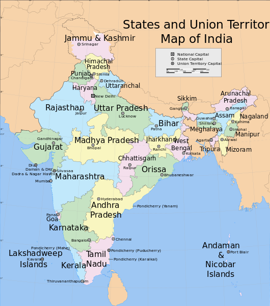
India States and Union Territories map |
|||||||||
| Description |
Map of India, showing the states, union territories and their capitals. |
|||||||||
| Légende de la carte |
 |
|||||||||
| Date | ||||||||||
| Source |
Travail personnel |
|||||||||
| Créé par | ||||||||||
| Autorisation (Réutilisation de ce fichier) |
Moi, en tant que détenteur des droits d’auteur sur cette œuvre, je la publie sous la licence suivante : Ce fichier est disponible selon les termes de la licence Creative Commons Attribution – Partage dans les Mêmes Conditions 3.0 (non transposée).
|
|||||||||
| Données géotemporelles | ||||||||||
| Date représentée | 2e moitié de XXe siècle et XXIe siècle | |||||||||
| Système de coordonnées | conic | |||||||||
| Rectangle englobant |
|
|||||||||
| Géoréférencement | Si c'est inapproprié, définissez warp_status = skip pour masquer. | |||||||||
| Données d'archives | ||||||||||
| Notes | Part of WikiProject India Maps | |||||||||

Notes
Depiction of India's borders
- The territorial boundaries of India are shown as per the actual ground situation in accordance with international practices followed by the United Nations ([1], [2]) and the National Geographic Society ([3], [4])
- This map is meant to be for illustrative purpose only and is not authenticated by official government sources. Please check the list of sources and references used to create the map for a measure of accuracy and verifiability.
- The usage of these maps in India, Pakistan and China are governed by different laws that restrict depictions of boundaries other than what is officially recognized by the state. Please check local laws and modify the map accordingly before use.
Explanation of disputed boundaries


- Boundary of Indian claim : The territory India claims is legally theirs, but the claim is disputed by China and Pakistan.
- Line of Control/Line of Conflict : The de facto administrative boundary recognised by the international community. This UN ceasefire line is considered as a temporary solution to an ongoing conflict since the departure of the British Raj.
Borders of disputed regions
The depicted extent of the former territory of the British Indian Empire, succeeded by Republic of India, may not be accepted by few countries as legal due to ongoing border disputes:
- The northern Himalayan region of the disputed territory Indian-administered Kashmir is claimed by India including (Pakistan-administered Kashmir) and the Chinese-occupied territory of (Ladakh plateau). Since 1972, it is divided between all three countries. See also Line of Control and Line of Actual Control.
- Siachen glacier (shown white) is an actively contested region between India and Pakistan. Since 1984, the region is under Indian control.
- The northeastern territory of Arunachal Pradesh is almost entirely claimed by China as part of its Tibetan territory.
- Minor areas of eastern Kashmir's Ladakh division, Himachal Pradesh and Uttarakhand on the Chinese frontier are claimed by China. These areas are under Indian control.
- A small area of Uttarakhand adjoining the Nepal border along the Sarda river is disputed between the two countries.
For a detailed map of all disputed regions in South Asia, see Image:India disputed areas map.svg
Internal borders
The borders of the state of Meghalaya, Assam and Arunachal Pradesh are shown as interpreted from the North-Eastern Areas (Reorganisation) Act, 1971, but has yet to be verified.
Territorial waters
The limit of the territorial waters of India extends to twelve nautical miles measured from the appropriate baseline. See this for more information.
Historique du fichier
Cliquer sur une date et heure pour voir le fichier tel qu'il était à ce moment-là.
| Date et heure | Vignette | Dimensions | Utilisateur | Commentaire | |
|---|---|---|---|---|---|
| actuel | 7 août 2006 à 17:41 | | 1 639 × 1 852 (304 kio) | Planemad | {{WikiProject_India_Maps |Title=India States and Union Territories map |Description=Map of India, showing the states, union territories and their capitals. |Source=. |Date=July 23 2006 |Author=w:user:Planemad |Thumbdir=CHANGE }} |
Utilisation du fichier
Aucune page n’utilise ce fichier.
Usage global du fichier
Les autres wikis suivants utilisent ce fichier :
- Utilisation sur cs.wikipedia.org
- Utilisation sur de.wikipedia.org
- Utilisation sur en.wikipedia.org
- Utilisation sur it.wikipedia.org
- Utilisation sur kn.wikipedia.org
- Utilisation sur nl.wikipedia.org
- Utilisation sur outreach.wikimedia.org
- Utilisation sur sq.wikipedia.org
- Utilisation sur te.wikipedia.org