
Fichier:Gwash map02.jpg
Fichier d’origine (3 227 × 2 390 pixels, taille du fichier : 1,77 Mio, type MIME : image/jpeg)
Ce fichier et sa description proviennent de Wikimedia Commons.
Description
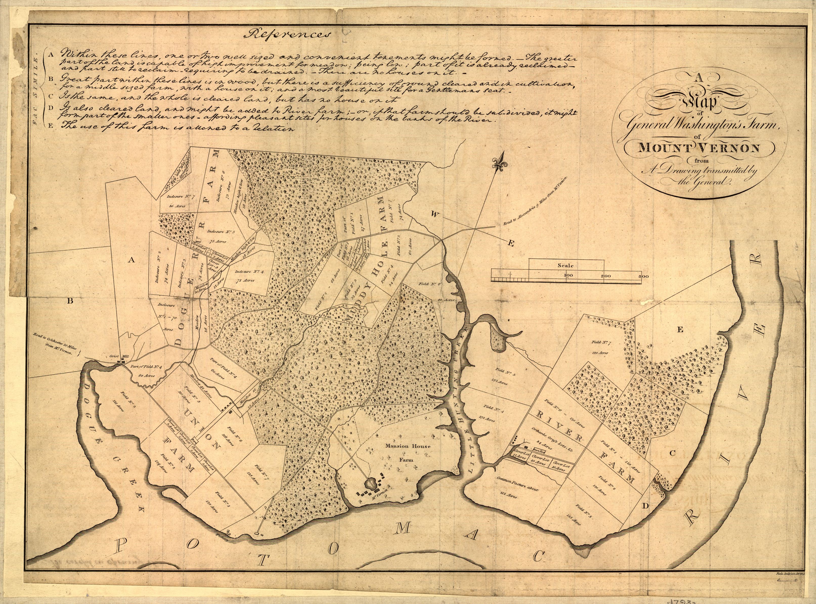
Map of Mount Vernon, residence of George Washington made by himself.
A map of General Washington's farm of Mount Vernon from a drawing transmitted by the General.
Uploaded from http://hdl.loc.gov/loc.gmd/g3882m.ct000367.
Notes from Library of Congress page:
CREATED/PUBLISHED [S.l., 1801]
NOTES Removed from: Letters from His Excellency George Washington, to Arthur Young, [etc.]. London, 1801. Opp. p. (E312.75.A27 Rare Book Rm.)
Scale 1:6,336.
SUBJECTS Mount Vernon (Va. : Estate)--Maps--Early works to 1800. United States--Virginia--Mount Vernon (Estate)
MEDIUM 1 map ; 37 x 52 cm.
CALL NUMBER G3882.M7 1793 .W34 1801 TIL Vault
REPOSITORY Library of Congress Geography and Map Division Washington, D.C. 20540-4650
DIGITAL ID g3882m ct000367

|
Cette map est disponible sur la Geography & Map Division de la Bibliothèque du Congrès des États-Unis sous le numéro d’identification g3882m.ct000367.
Ce bandeau n’indique rien sur le statut de l’œuvre au regard du droit d'auteur. Un bandeau de droit d’auteur est requis. Voir Commons:À propos des licences pour plus d’informations.
|
Conditions d’utilisation
|
Cette œuvre est également dans le domaine public dans tous les pays pour lesquels le droit d’auteur a une durée de vie de 70 ans ou moins après la mort de l’auteur.
| |
| Ce fichier a été identifié comme étant exempt de restrictions connues liées au droit d’auteur, y compris tous les droits connexes et voisins. | |
Historique du fichier
Cliquer sur une date et heure pour voir le fichier tel qu'il était à ce moment-là.
| Date et heure | Vignette | Dimensions | Utilisateur | Commentaire | |
|---|---|---|---|---|---|
| actuel | 1 octobre 2006 à 04:17 | | 3 227 × 2 390 (1,77 Mio) | Clindberg | Reupload from http://hdl.loc.gov/loc.gmd/g3882m.ct000367 with higher resolution; change license (not USGov but is PD-old) |
| 6 juin 2005 à 15:01 |  | 804 × 600 (138 kio) | Herrick~commonswiki | Map of Mount Vernon, residence of George Washington made by himself. A map of General Washington's farm of Mount Vernon from a drawing transmitted by the General. {{PD-USGov}} Washington, George, 1732-1799. CREATED/PUBLISHED [S.l., 1801] NOTES |
Utilisation du fichier
La page suivante utilise ce fichier :
Usage global du fichier
Les autres wikis suivants utilisent ce fichier :
- Utilisation sur de.wikipedia.org
- Utilisation sur en.wikipedia.org
- Utilisation sur it.wikipedia.org
- Utilisation sur ja.wikipedia.org
- Utilisation sur ko.wikipedia.org
- Utilisation sur nl.wikipedia.org
- Utilisation sur pt.wikipedia.org