
Fichier:VietnameseProvincesMapTiengViet.png
Taille de cet aperçu : 360 × 600 pixels. Autres résolutions : 144 × 240 pixels | 428 × 713 pixels.
Fichier d’origine (428 × 713 pixels, taille du fichier : 45 kio, type MIME : image/png)
Ce fichier et sa description proviennent de Wikimedia Commons.
Description
| Description |
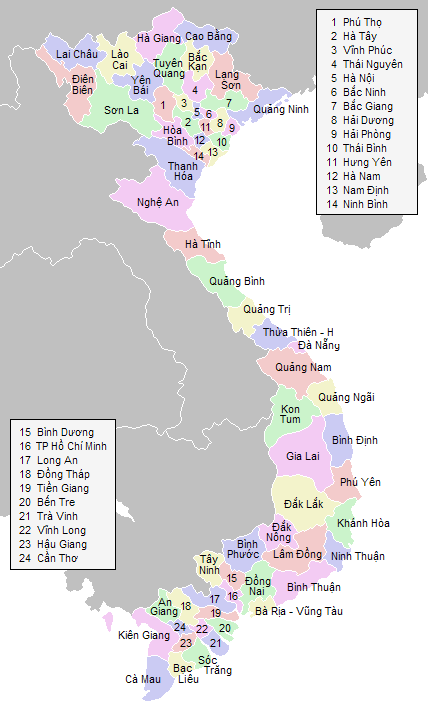
English: Labeled map of Vietnamese provinces |
| Source | Travail personnel |
| Auteur | Vardion |
Conditions d’utilisation

|
Vous avez la permission de copier, distribuer et modifier ce document selon les termes de la GNU Free Documentation License version 1.2 ou toute version ultérieure publiée par la Free Software Foundation, sans sections inaltérables, sans texte de première page de couverture et sans texte de dernière page de couverture. Un exemplaire de la licence est inclus dans la section intitulée GNU Free Documentation License. |
| Ce fichier est disponible selon les termes de la licence Creative Commons Attribution – Partage dans les Mêmes Conditions 3.0 (non transposée). | ||
| ||
| Ce bandeau de licence a été ajouté à ce fichier dans le cadre de la procédure de mise à jour des licences des images sous GFDL. |
Historique du fichier
Cliquer sur une date et heure pour voir le fichier tel qu'il était à ce moment-là.
| Date et heure | Vignette | Dimensions | Utilisateur | Commentaire | |
|---|---|---|---|---|---|
| actuel | 30 août 2018 à 09:40 | | 428 × 713 (45 kio) | 4nn1l2 | Reverted to version as of 23:28, 20 January 2006 (UTC) COM:OW |
| 30 août 2018 à 04:48 |  | 1 621 × 2 000 (6,86 Mio) | H.V.T Pro-4 | Merge "Hà Tây" into "Hà Nội" | |
| 21 janvier 2006 à 01:28 |  | 428 × 713 (45 kio) | Vardion | more corrections | |
| 21 janvier 2006 à 01:15 |  | 428 × 713 (45 kio) | Vardion | hopefully including both corrections on the same map... | |
| 21 janvier 2006 à 01:11 |  | 428 × 713 (45 kio) | Mxn | Reverted to earlier revision | |
| 21 janvier 2006 à 01:10 |  | 428 × 713 (45 kio) | Mxn | Reverted to earlier revision | |
| 21 janvier 2006 à 00:52 |  | 428 × 713 (45 kio) | Vardion | spelling | |
| 20 janvier 2006 à 23:59 |  | 428 × 713 (45 kio) | Vardion | correcting boundary between Dien Bien and Lai Chau provinces | |
| 15 juin 2005 à 23:52 |  | 428 × 713 (45 kio) | Vardion | Labeled map of Vietnamese provinces. Made for Wikipedia by uploader. {{GDFL}} |
Utilisation du fichier
Les 2 pages suivantes utilisent ce fichier :
Usage global du fichier
Les autres wikis suivants utilisent ce fichier :
- Utilisation sur an.wikipedia.org
- Utilisation sur bg.wikipedia.org
- Utilisation sur he.wikipedia.org
- Utilisation sur hu.wikipedia.org
- Utilisation sur id.wikipedia.org
- Utilisation sur tg.wikipedia.org
- Utilisation sur tl.wikipedia.org
- Utilisation sur tr.wikipedia.org
- Utilisation sur vi.wikipedia.org