
Fichier:Tsushima Omega Tower 1977 2.jpg

Taille de cet aperçu : 799 × 600 pixels. Autres résolutions : 320 × 240 pixels | 640 × 480 pixels | 1 023 × 768 pixels | 1 107 × 831 pixels.
Fichier d’origine (1 107 × 831 pixels, taille du fichier : 251 kio, type MIME : image/jpeg)
Ce fichier et sa description proviennent de Wikimedia Commons.
Description
| Description |
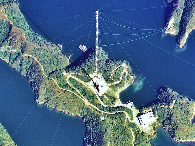
English: Shushi-Wan Omega Transmitter (station H) of the Omega navigation system, an obsolete worldwide navigation system, which transmitted in the VLF band on 10 - 14 kHz. The antenna, situated near Shushi-Wan on Tsushima Island was an umbrella antenna consisting of a 389-metre tall tubular steel mast, insulated against ground, with 14 wires extending diagonally from the top to the ground. This mast, which was built in 1973 and which was the tallest structure in Japan (and perhaps the tallest tubular steel mast ever built) was dismantled in 1998.
日本語: 対馬オメガ局。 |
|||
| Date | ||||
| Source | Japan Ministry of Land, Infrastructure and Transport. [1] | |||
| Auteur | retouch: Qurren (talk). | |||
| Autres versions |
|
| Lieu de la prise de vue | | Voir cet endroit et d’autres images sur : OpenStreetMap |
|---|
Conditions d’utilisation

|
Le détenteur des droits d’auteur de ce fichier, Ministère du Territoire, des Infrastructures, des Transports et du Tourisme, autorise n’importe qui à l’utiliser pour n’importe quelle utilisation, pourvu que le détenteur des droits d’auteur soit correctement attribué. La redistribution, les œuvres dérivées, l’utilisation commerciale et toutes les autres utilisations sont autorisées. |
Attribution:
Copyright © National Land Image Information (Color Aerial Photographs), Ministry of Land, Infrastructure, Transport and Tourism
|
 |
This image is copyrighted by the Ministry of Land, Infrastructure, Transport and Tourism of Japan. For terms of use, see the stipulation to use of National Land Information (in Japanese) and message from MLIT (in Japanese and English). When you display this image on an article, include the following phrase in the description: "Made based on National Land Image Information (Color Aerial Photographs), Ministry of Land, Infrastructure, Transport and Tourism".
|
Historique du fichier
Cliquer sur une date et heure pour voir le fichier tel qu'il était à ce moment-là.
| Date et heure | Vignette | Dimensions | Utilisateur | Commentaire | |
|---|---|---|---|---|---|
| actuel | 6 octobre 2013 à 16:09 | | 1 107 × 831 (251 kio) | Qurren | == {{int:filedesc}} == {{Information |Description={{en|1=en:Tsushima Omega Tower.}} {{ja|1=ja:対馬オメガ局。}} |Source=Japan Ministry of Land, Infrastructure and Transport. [http://w3land.mlit.go.jp/cgi-bin/WebGIS2/WC_AirPhoto.cgi?IT... |
Utilisation du fichier
La page suivante utilise ce fichier :
Usage global du fichier
Les autres wikis suivants utilisent ce fichier :
- Utilisation sur en.wikipedia.org
- Utilisation sur ja.wikipedia.org
- Utilisation sur ko.wikipedia.org
- Utilisation sur uk.wikipedia.org
- Utilisation sur www.wikidata.org