
Fichier:Quebec1775FrenchMap.jpg
Taille de cet aperçu : 796 × 600 pixels. Autres résolutions : 319 × 240 pixels | 637 × 480 pixels | 1 020 × 768 pixels | 1 280 × 964 pixels | 2 560 × 1 928 pixels | 3 616 × 2 724 pixels.
Fichier d’origine (3 616 × 2 724 pixels, taille du fichier : 2,96 Mio, type MIME : image/jpeg)
Ce fichier et sa description proviennent de Wikimedia Commons.
Description
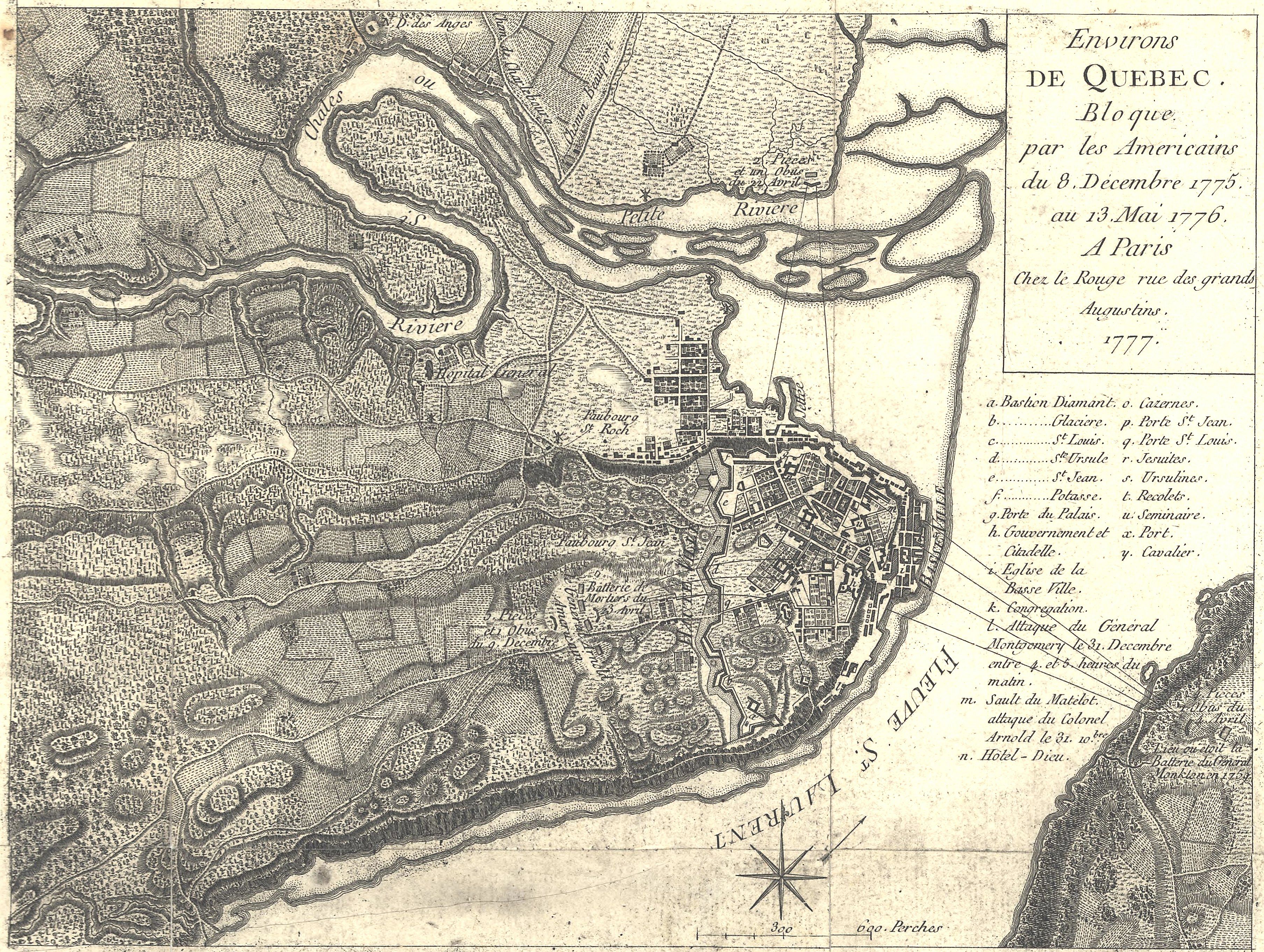
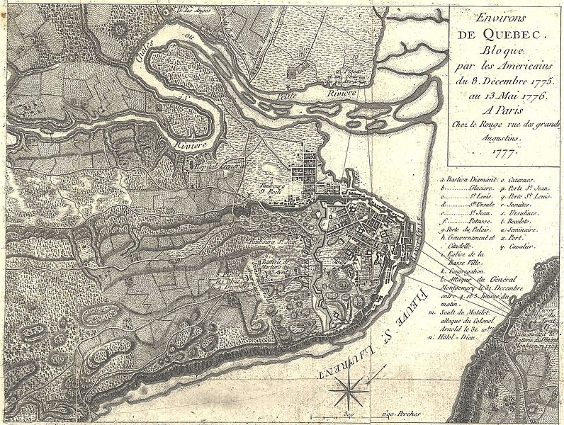
| Georges-Louis Le Rouge : Français : Environs de Quebec. Bloque par les Americains du 8. Decembre 1775 au 13. Mai 1776.
( |
|||||||||||||||||||||||
|---|---|---|---|---|---|---|---|---|---|---|---|---|---|---|---|---|---|---|---|---|---|---|---|
| Artiste |
|
||||||||||||||||||||||
| Titre |
Français : Environs de Quebec. Bloque par les Americains du 8. Decembre 1775 au 13. Mai 1776. |
||||||||||||||||||||||
| Description |
English: This is a 1777 French map showing the Battle and Siege of Quebec, December 1775 to May 1776. It has had its border cropped, and had slight contrast and brightness adjustments made.
The caption reads: Environs de Quebec Bloque par les Americains du 8. December 1775 au 13. Mai 1776. Translated: Quebec area besieged by the Americans, December 8, 1775 to May 13, 1776. |
||||||||||||||||||||||
| Date | 1777 | ||||||||||||||||||||||
| Source / photographe |
|
||||||||||||||||||||||

Conditions d’utilisation
|
Cette œuvre est également dans le domaine public dans tous les pays pour lesquels le droit d’auteur a une durée de vie de 100 ans ou moins après la mort de l’auteur. | |
| Ce fichier a été identifié comme étant exempt de restrictions connues liées au droit d’auteur, y compris tous les droits connexes et voisins. | |
Historique du fichier
Cliquer sur une date et heure pour voir le fichier tel qu'il était à ce moment-là.
| Date et heure | Vignette | Dimensions | Utilisateur | Commentaire | |
|---|---|---|---|---|---|
| actuel | 6 avril 2016 à 23:43 | | 3 616 × 2 724 (2,96 Mio) | Gwillhickers | sharper image |
| 15 février 2009 à 05:02 |  | 3 616 × 2 724 (2,53 Mio) | Magicpiano | {{Information |Description={{en|1=This is a 1777 French map showing the Battle and Siege of Quebec, December 1775 to May 1776. It has had its border cropped, and had slight contrast and brightness adjustments made. The caption reads: Environs de Quebec |
Utilisation du fichier
Les 2 pages suivantes utilisent ce fichier :
Usage global du fichier
Les autres wikis suivants utilisent ce fichier :
- Utilisation sur de.wikipedia.org
- Utilisation sur en.wikipedia.org
- Utilisation sur it.wikipedia.org
- Utilisation sur ja.wikipedia.org
- Utilisation sur ro.wikipedia.org
- Utilisation sur uk.wikipedia.org
- Utilisation sur zh.wikipedia.org