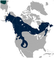
Fichier:American Three-toed Woodpecker Picoides dorsalis distribution map 2.png

Le contenu de la page n’est pas pris en charge dans d’autres langues.
Une page de Wikipédia, l'encyclopédie libre.

Fichier d’origine(756 × 800 pixels, taille du fichier : 129 kio, type MIME : image/png)

Ce fichier et sa description proviennent de Wikimedia Commons.

Description

Description
English: Geographical distribution of the American Three-toed Woodpecker Picoides dorsalis (navy). A small portion of the Eurasian Three-toed Woodpecker Picoides tridactylus range is visible in the upper left corner (deep cyan). Includes state and province borders.

Note: IUCN does not recognize Picoides dorsalis as separate species.

The map was created using the Generic Mapping Tools, GMT, version 5.1.2.
Date
Source

Travail personnel avec: the IUCN Red List spatial data to draw the borders of the Picoides dorsalis and Picoides tridactylus range:
http://maps.iucnredlist.org/map.html?id=22727137
Credit for the spatial data:
BirdLife International and NatureServe (2014) Bird Species Distribution Maps of the World. 2014. Picoides tridactylus. In: IUCN 2014. The IUCN Red List of Threatened Species. Version 2014.3. http://www.iucnredlist.org. Downloaded on 26 May 2015.
Species account:
http://www.iucnredlist.org/details/22727137/0
BirdLife International 2014. Picoides tridactylus. The IUCN Red List of Threatened Species. Version 2014.3. <www.iucnredlist.org>. Downloaded on 26 May 2015.

 
Cette carte a été créée avec GMT.
Auteur Darekk2 using the IUCN Red List spatial data
Autres versions Without Picoides tridactylus:
American Three-toed Woodpecker Picoides dorsalis distribution map.png

Conditions d’utilisation

Attribution: The author of the work and the IUCN Red List spatial data.
You must provide the appropriate credit for the IUCN Red List spatial data:
BirdLife International and NatureServe (2014) Bird Species Distribution Maps of the World. 2014. Picoides tridactylus. In: IUCN 2014. The IUCN Red List of Threatened Species. Version 2014.3. http://www.iucnredlist.org. Downloaded on 26 May 2015.

w:fr:Creative Commons
paternité partage à l’identique
Attribution: The author of the work
and the IUCN Red List spatial data
Vous êtes libre :
  • de partager – de copier, distribuer et transmettre cette œuvre
  • d’adapter – de modifier cette œuvre
Sous les conditions suivantes :
  • paternité – Vous devez donner les informations appropriées concernant l'auteur, fournir un lien vers la licence et indiquer si des modifications ont été faites. Vous pouvez faire cela par tout moyen raisonnable, mais en aucune façon suggérant que l’auteur vous soutient ou approuve l’utilisation que vous en faites.
  • partage à l’identique – Si vous modifiez, transformez, ou vous basez sur cette œuvre, vous devez distribuer votre contribution sous la même licence ou une licence compatible avec celle de l’original.

Légendes

Ajoutez en une ligne la description de ce que représente ce fichier

Éléments décrits dans ce fichier

dépeint

image/png

368cc7891e05ada5c94d07abb36f60eec1d9ed79

132 062 octet

800 pixel

756 pixel

Historique du fichier

Cliquer sur une date et heure pour voir le fichier tel qu'il était à ce moment-là.

Date et heureVignetteDimensionsUtilisateurCommentaire
actuel27 mai 2015 à 04:29Vignette pour la version du 27 mai 2015 à 04:29756 × 800 (129 kio)Darekk2thinner borders of states
26 mai 2015 à 20:48Vignette pour la version du 26 mai 2015 à 20:48757 × 800 (133 kio)Darekk2thicker borders of states
26 mai 2015 à 20:21Vignette pour la version du 26 mai 2015 à 20:21756 × 800 (125 kio)Darekk2User created page with UploadWizard

Les 2 pages suivantes utilisent ce fichier :

Usage global du fichier

Les autres wikis suivants utilisent ce fichier :