Aller au contenu

Fichier:1768 James Craig Map of New Town, Edinburgh, Scotland (First Plan of New Town) - Geographicus - Edinburgh-craig-1768.jpg
Le contenu de la page n’est pas pris en charge dans d’autres langues.
Une page de Wikipédia, l'encyclopédie libre.

Fichier d’origine(5 000 × 3 508 pixels, taille du fichier : 6,08 Mio, type MIME : image/jpeg)

Ce fichier et sa description proviennent de Wikimedia Commons.

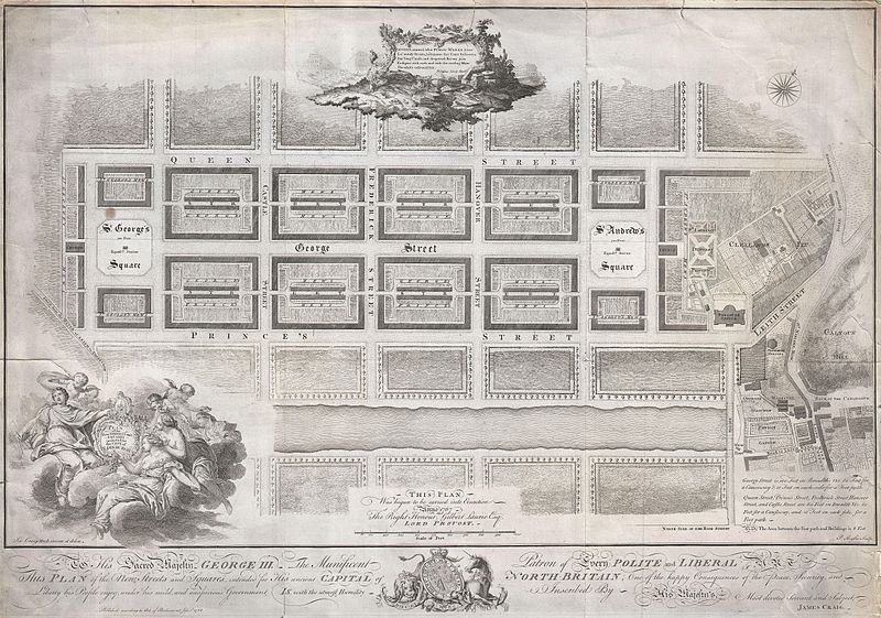
Plan of the New Streets and Squares intended for the city of Edinburgh.
Artiste
Titre
Plan of the New Streets and Squares intended for the city of Edinburgh.
Description
English: Drafted for the city planning committee in 1768 by James Craig, this is the definitive plan of Edinburgh, Scotland’s New Town. Oriented to the North, this plan details the streets of Edinburgh north of the Loch Nor (today the Prince’s Street Gardens) between St. George’s Square (modern day Charlotte Square) and St. Andrews Square. A dedication to King George the III illustrates the lower part of the map. An elaborate title cartouche decorates the lower left hand quadrant. Thompson’s poem appears in a secondary cartouche at the top center. In 1766 the City Fathers of Edinburgh lead by Lord Provost George Drummond instituted a plan to extend the city’s border to encompass the field’s north of the Nor Loch. The plan, intended to modernize the city and ease the crowded conditions of the old Royal Burgh, was turned into a competition. James Craig, an Edinburgh native, having around this time just completed his apprenticeship as a mason, found the he had a fine hand for drafting. Inspired by his uncle James Thomson’s well known poem Liberty , August, around, what Public Works I see, Lo’ stately Streets, lo’ Squares that Court the breeze, See’ long Canals, and deepened Rivers join Eash part with each, and with the circling Main The whole enlivened Isle… Craig submitted this plan. Though conservative in its vision, Craig’s plan won the city’s design contest and he was awarded with the “Freedom of the City” in 1767. Sadly the Lord Provost George Drummond who instituted the contest died before his dream of expanding the city was realized. It was left to his successor, the Lord Provost Gilbert Laurie, who is named on this map, to realize Craig’s plan. Today the streets are laid out much as Craig envisioned them with broad east –west avenues separating housing blocks bisected by smaller mews. Drawn by James Craig and engraved by P. Begbie in 1768. When this plan was printed in 1768, only 500 were issued. With such a small printing run as an independently issued map, we can safely assume that very few examples, other than the one you see here, have survived to this day. Only one recorded example of this map has appeared at auction in the last 30 years. Dated and copyrighted “Published according to Act of Parliament, Jan. 1st, 1768.
Date 1768 (dated)
Dimensions hauteur : 18 pouces (45,7 cm) ; largeur : 26 pouces (66 cm)
dimensions QS:P2048,18U218593
dimensions QS:P2049,26U218593
Numéro d’inventaire
liens Geographicus : Edinburgh-craig-1768
Source / photographe
Autorisation
(Réutilisation de ce fichier)
Ceci est une reproduction photographique fidèle d'une œuvre d'art originale en deux dimensions. L'œuvre d'art elle-même est dans le domaine public pour la raison suivante :
Public domain

Cette œuvre est également dans le domaine public dans tous les pays pour lesquels le droit d’auteur a une durée de vie de 100 ans ou moins après la mort de l’auteur.


Vous devez aussi inclure un modèle indiquant pourquoi cette œuvre est dans le domaine public aux États-Unis.
La position officielle de la Fondation Wikimedia est que « les représentations fidèles des œuvres d'art du domaine public en deux dimensions sont dans le domaine public et les exigences contraires sont une attaque contre le concept même de domaine public ». Pour plus de détails, voir Commons:Quand utiliser le bandeau PD-Art.
Cette reproduction photographique est donc également considérée comme étant élevée dans le domaine public. Merci de noter qu'en fonction des lois locales, la réutilisation de ce contenu peut être interdite ou restreinte dans votre juridiction. Voyez Commons:Reuse of PD-Art photographs.

Légendes

Ajoutez en une ligne la description de ce que représente ce fichier

Éléments décrits dans ce fichier

dépeint

image/jpeg

d77403877c867d6b8f622485ff0d65fc8369261d

6 378 004 octet

3 508 pixel

5 000 pixel

Historique du fichier

Cliquer sur une date et heure pour voir le fichier tel qu'il était à ce moment-là.

Date et heureVignetteDimensionsUtilisateurCommentaire
actuel22 mars 2011 à 23:16Vignette pour la version du 22 mars 2011 à 23:165 000 × 3 508 (6,08 Mio)BotMultichillT{{subst:User:Multichill/Geographicus |link=http://www.geographicus.com/P/AntiqueMap/Edinburgh-craig-1768 |product_name=1768 James Craig Map of New Town, Edinburgh, Scotland (First Plan of New Town) |map_title=Plan of the New Streets and Squares intended

Usage global du fichier