
Fichier:Pakistan-Waziristan-Map.png

Taille de cet aperçu : 606 × 599 pixels. Autres résolutions : 243 × 240 pixels | 486 × 480 pixels | 700 × 692 pixels.
Fichier d’origine (700 × 692 pixels, taille du fichier : 96 kio, type MIME : image/png)
Ce fichier et sa description proviennent de Wikimedia Commons.
Description
| Description |
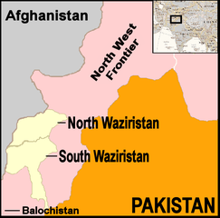
English: Map showing location of North and South Waziristan in northern Pakistan and bordering on Afghanistan |
||||
| Date | |||||
| Source | drawn by uploader using Jasc Paint Shop, using as insert map a reference map in Public Domain from the United States Central Intelligence Agency | ||||
| Auteur | Thaddeus P. Bejnar | ||||
| Autorisation (Réutilisation de ce fichier) |
Public Domain, I (Thaddeus P. Bejnar) hereby release this work to the Public Domain | ||||
| Autres versions |
|


.svg)


.svg)


.svg)


_Territory_Change_2014-2016.gif)

_(within_Northern_Syria).svg)


.png)
.svg)


_map.png)
.svg)


.svg)


Conditions d’utilisation
| Moi, propriétaire des droits d’auteur sur cette œuvre, la place dans le domaine public. Ceci s'applique dans le monde entier. Dans certains pays, ceci peut ne pas être possible ; dans ce cas : J’accorde à toute personne le droit d’utiliser cette œuvre dans n’importe quel but, sans aucune condition, sauf celles requises par la loi. |
Historique du fichier
Cliquer sur une date et heure pour voir le fichier tel qu'il était à ce moment-là.
| Date et heure | Vignette | Dimensions | Utilisateur | Commentaire | |
|---|---|---|---|---|---|
| actuel | 7 novembre 2006 à 23:59 | | 700 × 692 (96 kio) | Bejnar | {{Information |Description=Map showing location of North and South Waziristan in northern Pakistan and bordering on Afghanistan |Source=drawn by uploader using Jasc Paint Shop |Date=7 November 2006 |Author=Thaddeus P. Bejnar |Permission=Public Domain, I ( |
Utilisation du fichier
Les 2 pages suivantes utilisent ce fichier :
Usage global du fichier
Les autres wikis suivants utilisent ce fichier :
- Utilisation sur ar.wikipedia.org
- Utilisation sur ca.wikipedia.org
- Utilisation sur cs.wikipedia.org
- Utilisation sur cy.wikipedia.org
- Utilisation sur de.wikinews.org
- Utilisation sur en.wikinews.org
- 17 troops killed in bombing on Afghanistan-Pakistan border; Separate bombing kills dozens of civilians
- High level al-Qaeda leader reported dead
- Pakistani military launches ground offensive against Taliban and al-Qaeda
- Pakistan: Twelve militants killed in recent fighting
- Suspected US drone attack kills at least fourteen in Pakistan
- Utilisation sur it.wikipedia.org
- Utilisation sur nl.wikipedia.org
- Utilisation sur pt.wikipedia.org
- Utilisation sur pt.wikinews.org