
Fichier:OSPAR Commission area map.svg

Taille de cet aperçu PNG pour ce fichier SVG : 555 × 600 pixels. Autres résolutions : 222 × 240 pixels | 444 × 480 pixels | 710 × 768 pixels | 947 × 1 024 pixels | 1 894 × 2 048 pixels | 740 × 800 pixels.
Fichier d’origine (Fichier SVG, nominalement de 740 × 800 pixels, taille : 202 kio)
Ce fichier et sa description proviennent de Wikimedia Commons.
Description
| Description |
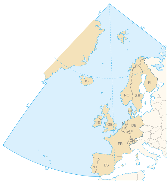
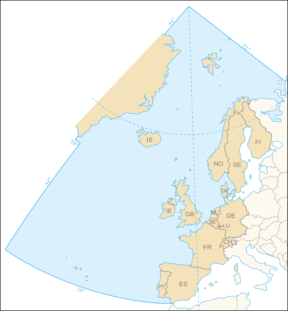
English: Map of the marine area and the 15 contracting parties of the OSPAR Commission for the protection of the marine environment of the North-East Atlantic.
Français : Carte de la zone maritime et des 15 pays signataires de la Commission OSPAR pour la protection du milieu marin de l'Atlantique du nord-est. |
||
| Date | |||
| Source | Own work, based upon the map (corrected following the article 1 of the 1992 OSPAR Convention) available on the OSPAR Commission's site | ||
| Auteur | Eric Gaba (Sting - fr:Sting) | ||
| Autorisation (Réutilisation de ce fichier) |
|
Conditions d’utilisation
Moi, en tant que détenteur des droits d’auteur sur cette œuvre, je la publie sous la licence suivante :
Ce fichier est disponible selon les termes de la licence Creative Commons Attribution – Partage dans les Mêmes Conditions 2.5 Générique
- Vous êtes libre :
- de partager – de copier, distribuer et transmettre cette œuvre
- d’adapter – de modifier cette œuvre
- Sous les conditions suivantes :
- paternité – Vous devez donner les informations appropriées concernant l'auteur, fournir un lien vers la licence et indiquer si des modifications ont été faites. Vous pouvez faire cela par tout moyen raisonnable, mais en aucune façon suggérant que l’auteur vous soutient ou approuve l’utilisation que vous en faites.
- partage à l’identique – Si vous modifiez, transformez, ou vous basez sur cette œuvre, vous devez distribuer votre contribution sous la même licence ou une licence compatible avec celle de l’original.
Historique du fichier
Cliquer sur une date et heure pour voir le fichier tel qu'il était à ce moment-là.
| Date et heure | Vignette | Dimensions | Utilisateur | Commentaire | |
|---|---|---|---|---|---|
| actuel | 9 novembre 2006 à 23:44 | | 740 × 800 (202 kio) | Sting | White background |
| 9 novembre 2006 à 23:31 |  | 740 × 800 (202 kio) | Sting | {{Information| |Description=Map of the marine area and the 15 contracting parties of the OSPAR Commission for the protection of the marine environment of the North-East Atlantic |Source=Own work, based upon [http://www.ospar.org/eng/html/welcome.html the |
Utilisation du fichier
Les 2 pages suivantes utilisent ce fichier :
Usage global du fichier
Les autres wikis suivants utilisent ce fichier :
- Utilisation sur ast.wikipedia.org
- Utilisation sur ca.wikipedia.org
- Utilisation sur cs.wikipedia.org
- Utilisation sur da.wikipedia.org
- Utilisation sur de.wikipedia.org
- Utilisation sur de.wiktionary.org
- Utilisation sur en.wikipedia.org
- Utilisation sur es.wikipedia.org
- Utilisation sur gl.wikipedia.org
- Utilisation sur nl.wikipedia.org
- Utilisation sur no.wikipedia.org
- Utilisation sur pt.wikipedia.org
- Utilisation sur sk.wikipedia.org
- Utilisation sur sv.wikipedia.org