
Fichier:EU fishing agreements.png

Taille de cet aperçu : 800 × 370 pixels. Autres résolutions : 320 × 148 pixels | 640 × 296 pixels | 1 350 × 625 pixels.
Fichier d’origine (1 350 × 625 pixels, taille du fichier : 36 kio, type MIME : image/png)
Ce fichier et sa description proviennent de Wikimedia Commons.
Description
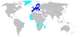
| Description | Map of countries or territories that have a fishing agreement with the EU (Greenland, Iceland, Faeroe, Norway, Mauritania, Senegal, Gambia, Guinea, Guinee Bissau, Cote d'Ivoire, Equatorial Guinea, Gabon, Angola, Mozambique, Comores, Seychelles, Madagascar, Fidji). |
| Date | |
| Source | Eurostat |
| Auteur | Popo le Chien (from fr) |
| Autorisation (Réutilisation de ce fichier) |
Public Domain |
Conditions d’utilisation
| Moi, propriétaire des droits d’auteur sur cette œuvre, la place dans le domaine public. Ceci s'applique dans le monde entier. Dans certains pays, ceci peut ne pas être possible ; dans ce cas : J’accorde à toute personne le droit d’utiliser cette œuvre dans n’importe quel but, sans aucune condition, sauf celles requises par la loi. |
Historique du fichier
Cliquer sur une date et heure pour voir le fichier tel qu'il était à ce moment-là.
| Date et heure | Vignette | Dimensions | Utilisateur | Commentaire | |
|---|---|---|---|---|---|
| actuel | 9 mars 2018 à 11:21 | | 1 350 × 625 (36 kio) | Maphobbyist | South Sudan border |
| 21 mars 2014 à 21:05 |  | 1 350 × 625 (28 kio) | F karlo | Croatia in EU | |
| 23 février 2008 à 00:13 |  | 1 350 × 625 (46 kio) | Hoshie | updated the map | |
| 7 juin 2006 à 14:25 |  | 1 350 × 625 (46 kio) | Popo le Chien | {{Information |Description=Map of countries or territories that have a fishing agreement with the EU (Greenland, Iceland, Faeroe, Norway, Mauritania, Senegal, Gambia, Guinea, Guinee Bissau, Cote d'Ivoire, Equatorial Guinea, Gabon, Angola, Mozambique, Com |
Utilisation du fichier
La page suivante utilise ce fichier :
Usage global du fichier
Les autres wikis suivants utilisent ce fichier :
- Utilisation sur is.wikipedia.org