
Fichier:Continental West Germanic languages.png

Taille de cet aperçu : 462 × 600 pixels. Autres résolutions : 185 × 240 pixels | 370 × 480 pixels | 591 × 768 pixels | 789 × 1 024 pixels | 1 796 × 2 332 pixels.
Fichier d’origine (1 796 × 2 332 pixels, taille du fichier : 539 kio, type MIME : image/png)
Ce fichier et sa description proviennent de Wikimedia Commons.


|
Cette image (de type linguistic map) devrait être recréée dans un format vectoriel, en tant que fichier SVG. Cela offrirait plusieurs avantages : voir Commons:Media for cleanup pour plus d'informations. Si une version SVG de cette image est déjà disponible, merci de bien vouloir l'envoyer. Après cela, remplacez ce modèle par {{vector version available|nouveau nom d'image.svg}}.
|
| Description |
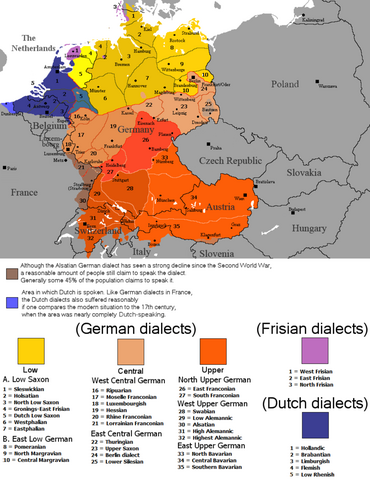
English: The dialectal ranges (not those of standard languages!) of the Continental West Germanic languages (Dutch/Frisian/German) after 1945 |
||
| Source |
|
||
| Auteur | Rex Germanus | ||
| Autorisation (Réutilisation de ce fichier) |
|

Historique du fichier
Cliquer sur une date et heure pour voir le fichier tel qu'il était à ce moment-là.
| Date et heure | Vignette | Dimensions | Utilisateur | Commentaire | |
|---|---|---|---|---|---|
| actuel | 26 septembre 2023 à 01:04 | | 1 796 × 2 332 (539 kio) | Гинц фон Гинценфельд | In dieser Version ist die Westfälische Linie genauer markiert. |
| 26 septembre 2023 à 00:52 |  | 1 796 × 2 332 (538 kio) | Гинц фон Гинценфельд | In dieser Version ist die Westfälische Linie genauer markiert. | |
| 25 septembre 2023 à 13:26 |  | 1 796 × 2 332 (535 kio) | Гинц фон Гинценфельд | In dieser Version ist die Westfälische Linie genauer markiert. | |
| 8 août 2017 à 22:01 |  | 898 × 1 166 (166 kio) | E-960 | Corrected location of city markers | |
| 6 mai 2017 à 11:19 |  | 898 × 1 166 (166 kio) | E-960 | Updated map to focus on Germany and the Benelux, also removed out of date areas, due to migration back to Germany after the fall of the Iron Curtain. | |
| 4 février 2017 à 19:49 |  | 1 028 × 1 196 (193 kio) | E-960 | Added place name of Wien, and Český Krumlov in local language. | |
| 4 février 2017 à 19:11 |  | 1 028 × 1 196 (193 kio) | E-960 | Adjusted place names reverting them to the local language of each individual country, also fixed the border between Belarus and Ukraine, and areas of German minority in Central and Eastern Europe. | |
| 12 août 2016 à 19:07 |  | 1 028 × 1 196 (154 kio) | Kontrollstellekundl | corr: Salzbaurg -> Salzburg Krummau -> Krumau Luxemburgish -> Luxembourgish Upper Sacon -> Upper Saxon + placement of various names | |
| 28 juillet 2014 à 14:15 |  | 1 028 × 1 196 (107 kio) | Crom daba | Shaded sub-dialect groupings a bit different so that they can be differentiated at a glance | |
| 4 septembre 2010 à 23:57 |  | 1 028 × 1 196 (132 kio) | Hans Erren | Geographic border corrections (Borkum, Markerwaard) Western ripuarian border corrected |
Utilisation du fichier
La page suivante utilise ce fichier :
Usage global du fichier
Les autres wikis suivants utilisent ce fichier :
- Utilisation sur ace.wikipedia.org
- Utilisation sur af.wikipedia.org
- Utilisation sur azb.wikipedia.org
- Utilisation sur be-tarask.wikipedia.org
- Utilisation sur bg.wikipedia.org
- Utilisation sur ce.wikipedia.org
- Utilisation sur da.wikipedia.org
- Utilisation sur de.wikipedia.org
- Utilisation sur en.wikipedia.org
- Utilisation sur en.wikivoyage.org
- Utilisation sur es.wikipedia.org
- Utilisation sur fa.wikipedia.org
- Utilisation sur ga.wikipedia.org
- Utilisation sur hr.wiktionary.org
- Utilisation sur id.wikipedia.org
- Utilisation sur ja.wikipedia.org
- Utilisation sur lij.wikipedia.org
- Utilisation sur mk.wikipedia.org
- Utilisation sur mn.wikipedia.org
- Utilisation sur pnb.wikipedia.org
- Utilisation sur ro.wikipedia.org
- Utilisation sur ru.wikipedia.org
- Utilisation sur simple.wikipedia.org
- Utilisation sur sl.wikipedia.org
- Utilisation sur sr.wikipedia.org
- Utilisation sur sv.wikipedia.org
- Utilisation sur uk.wikipedia.org
- Utilisation sur zh-min-nan.wikipedia.org